
Geographic Region: CHINA
Feature: YU-LIN POINT
|
Geographic Region: CHINA Feature: YU-LIN POINT |
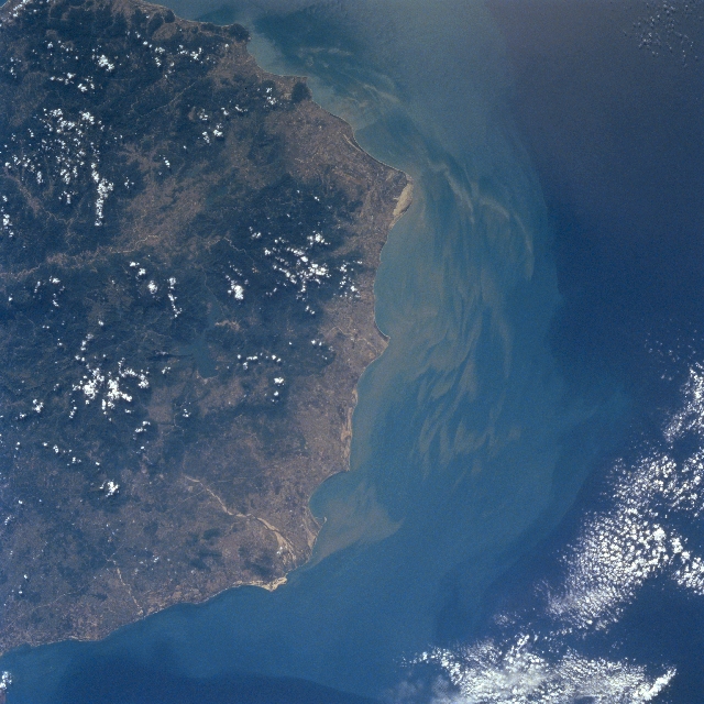 |
| STS087-701-053 Hainan Island, China November 1997 The southwest coast of Hainan Island, China's second largest island has a variety of landforms. Scattered clouds cover many of the higher mountainous features. Maximum elevations in the densely vegetated (dark terrain) mountains range from 2000 feet (610 m) to over 4000 feet (1220 m) above sea level. Numerous short flowing rivers including the Changhua River (light-colored, linear feature near bottom center) drain into the Gulf of Tonkin. Based on the sediment (plume) pattern and distribution along the coast, current flow is towards the south, southeast. The lighter-colored land areas show where a variety of agricultural activities are taking place on the coastal plains and in some of the river valleys. |
| Images: | All Available Images Low-Resolution 348k |
|
| Mission: | STS087 |
|
| Roll - Frame: | 701 - 53 |
|
| Geographical Name: | CHINA |
|
| Features: | YU-LIN POINT |
|
| Center Lat x Lon: | 19.0N x 108.5E |
|
| Film Exposure: | N | N=Normal exposure, U=Under exposed, O=Over exposed, F=out of Focus |
| Percentage of Cloud Cover-CLDP: | 10 |
|
| Camera:: | HB |
|
| Camera Tilt: | 9 | LO=Low Oblique, HO=High Oblique, NV=Near Vertical |
| Camera Focal Length: | 100 |
|
| Nadir to Photo Center Direction: | E | The direction from the nadir to the center point, N=North, S=South, E=East, W=West |
| Stereo?: | Y | Y=Yes there is an adjacent picture of the same area, N=No there isn't |
| Orbit Number: | 22 |
|
| Date: | 19971121 | YYYYMMDD |
| Time: | 030855 | GMT HHMMSS |
| Nadir Lat: | 19.1N |
Latitude of suborbital point of spacecraft |
| Nadir Lon: | 108.1E |
Longitude of suborbital point of spacecraft |
| Sun Azimuth: | 151 | Clockwise angle in degrees from north to the sun measured at the nadir point |
| Space Craft Altitude: | 150 | nautical miles |
| Sun Elevation: | 46 | Angle in degrees between the horizon and the sun, measured at the nadir point |
| Land Views: | MOUNTAIN, PLAIN |
|
| Water Views: | RIVER |
|
| Atmosphere Views: | |
|
| Man Made Views: | |
|
| City Views: | |
|
Photo is not associated with any sequences | ||
| NASA Home Page |
JSC Home Page |
JSC Digital Image Collection |
Earth Science & Remote Sensing |
|
This service is provided by the International Space Station program and the JSC Earth Science & Remote Sensing Unit, ARES Division, Exploration Integration Science Directorate.

|