
Geographic Region: THAILAND
Feature: LAKE HAN, MEKONG RIVER
|
Geographic Region: THAILAND Feature: LAKE HAN, MEKONG RIVER |
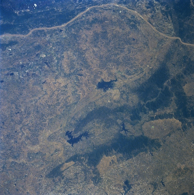 |
| STS087-701-040 Nong Han Lake, Thailand November 1997 A section of the muddy-looking Mekong River (linear, light-colored feature) that runs laterally across the top of the image is the border between Thailand (west of the river) and Laos (land area east of the river). A band of low, forested mountains (dark landscape) with a few maximum elevations barely exceeding 2100 feet (640 meters) above sea level are visible (middle right) as they form a gradual curving structure that crosses the Mekong River into Laos. Several reservoirs (very dark, irregular-shaped features-various sizes), including Nong Han Lake (near center of image), are discernible in the vicinity of the mountainous terrain in the bottom half of the image. Rice is the dominant farm crop that is produced in this region of the Khorat Plateau in northeastern Thailand. |
| Images: | All Available Images Low-Resolution 396k |
|
| Mission: | STS087 |
|
| Roll - Frame: | 701 - 40 |
|
| Geographical Name: | THAILAND |
|
| Features: | LAKE HAN, MEKONG RIVER |
|
| Center Lat x Lon: | 17.5N x 104.0E |
|
| Film Exposure: | N | N=Normal exposure, U=Under exposed, O=Over exposed, F=out of Focus |
| Percentage of Cloud Cover-CLDP: | 0 |
|
| Camera:: | HB |
|
| Camera Tilt: | 10 | LO=Low Oblique, HO=High Oblique, NV=Near Vertical |
| Camera Focal Length: | 100 |
|
| Nadir to Photo Center Direction: | NE | The direction from the nadir to the center point, N=North, S=South, E=East, W=West |
| Stereo?: | Y | Y=Yes there is an adjacent picture of the same area, N=No there isn't |
| Orbit Number: | 22 |
|
| Date: | 19971121 | YYYYMMDD |
| Time: | 030742 | GMT HHMMSS |
| Nadir Lat: | 17.2N |
Latitude of suborbital point of spacecraft |
| Nadir Lon: | 103.7E |
Longitude of suborbital point of spacecraft |
| Sun Azimuth: | 144 | Clockwise angle in degrees from north to the sun measured at the nadir point |
| Space Craft Altitude: | 151 | nautical miles |
| Sun Elevation: | 45 | Angle in degrees between the horizon and the sun, measured at the nadir point |
| Land Views: | MOUNTAIN, FOREST |
|
| Water Views: | RIVER, LAKE |
|
| Atmosphere Views: | |
|
| Man Made Views: | AGRICULTURE |
|
| City Views: | |
|
Photo is not associated with any sequences | ||
| NASA Home Page |
JSC Home Page |
JSC Digital Image Collection |
Earth Science & Remote Sensing |
|
This service is provided by the International Space Station program and the JSC Earth Science & Remote Sensing Unit, ARES Division, Exploration Integration Science Directorate.

|