
Geographic Region: THAILAND
Feature: UBOLRATNA RESERVOIR
|
Geographic Region: THAILAND Feature: UBOLRATNA RESERVOIR |
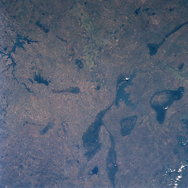 |
| STS087-701-037 Ubolratna Reservoir, Thailand November 1997 The Khorat Plateau, located in northeast Thailand, is an elevated plain that is broken only by an occasional, narrow, isolated mountain ridge (elongated, dark features). These low mountains (average elevations between 1500 feet - 457 meters and 2500 feet - 762 meters above sea level) are seen primarily in the right half (western side) of the image. Recognizable features in the image includes the Ubolratna Reservoir (dark, irregular shaped feature) located slightly right of center; an elongated but irregular shaped Lam Pao Reservoir (dark feature) along the left edge of the image; a small reservoir (dark feature) bottom center; and the linear-looking mountain ridges. The mottled-looking landscape shows the distribution pattern of small rice producing fields. |
| Images: | All Available Images Low-Resolution 390k |
|
| Mission: | STS087 |
|
| Roll - Frame: | 701 - 37 |
|
| Geographical Name: | THAILAND |
|
| Features: | UBOLRATNA RESERVOIR |
|
| Center Lat x Lon: | 17.0N x 102.5E |
|
| Film Exposure: | N | N=Normal exposure, U=Under exposed, O=Over exposed, F=out of Focus |
| Percentage of Cloud Cover-CLDP: | 0 |
|
| Camera:: | HB |
|
| Camera Tilt: | 9 | LO=Low Oblique, HO=High Oblique, NV=Near Vertical |
| Camera Focal Length: | 100 |
|
| Nadir to Photo Center Direction: | W | The direction from the nadir to the center point, N=North, S=South, E=East, W=West |
| Stereo?: | Y | Y=Yes there is an adjacent picture of the same area, N=No there isn't |
| Orbit Number: | 22 |
|
| Date: | 19971121 | YYYYMMDD |
| Time: | 030730 | GMT HHMMSS |
| Nadir Lat: | 16.9N |
Latitude of suborbital point of spacecraft |
| Nadir Lon: | 102.9E |
Longitude of suborbital point of spacecraft |
| Sun Azimuth: | 143 | Clockwise angle in degrees from north to the sun measured at the nadir point |
| Space Craft Altitude: | 151 | nautical miles |
| Sun Elevation: | 45 | Angle in degrees between the horizon and the sun, measured at the nadir point |
| Land Views: | MOUNTAIN |
|
| Water Views: | RESERVOIR |
|
| Atmosphere Views: | |
|
| Man Made Views: | AGRICULTURE |
|
| City Views: | |
|
Photo is not associated with any sequences | ||
| NASA Home Page |
JSC Home Page |
JSC Digital Image Collection |
Earth Science & Remote Sensing |
|
This service is provided by the International Space Station program and the JSC Earth Science & Remote Sensing Unit, ARES Division, Exploration Integration Science Directorate.

|