
Geographic Region: MALTA
Feature: MALTA, VALLETTA
|
Geographic Region: MALTA Feature: MALTA, VALLETTA |
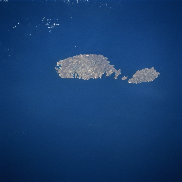 |
| STS085-750-057 Malta August 1997 Although small in size (122 square miles-316 square km), the independent republic of Malta is strategically located midway between the Strait of Gibraltar and the Suez Canal in the Mediterranean Sea. The country is made up of three inhabited islands that are visible in this image: the island of Malta, the largest, Gozo, and Comino, the smallest, is situated between the two larger islands. The capital and largest city, Valletta, is mainly built on a rocky peninsula along the northeast coast of Malta. Valletta can be identified even on this small image where the peninsula extends northeast between two natural harbors (small, narrow, dark features). The geological faulting in this area has produced numerous fine natural harbors around the periphery of Malta. Although the islands are composed of sedimentary rocks, mainly limestone and clays, the alkaline soils provide fertile conditions for the well-established agricultural economy. Precipitation amounts can be a problem in that the islands average only about 12 inches (32 cm) per year. Malta has few natural resources so the growth of tourism, especially since World War II, has gradually added to the Maltese economy. |
| Images: | All Available Images Low-Resolution 223k |
|
| Mission: | STS085 |
|
| Roll - Frame: | 750 - 57 |
|
| Geographical Name: | MALTA |
|
| Features: | MALTA, VALLETTA |
|
| Center Lat x Lon: | 36.0N x 14.5E |
|
| Film Exposure: | N | N=Normal exposure, U=Under exposed, O=Over exposed, F=out of Focus |
| Percentage of Cloud Cover-CLDP: | 0 |
|
| Camera:: | HB |
|
| Camera Tilt: | LO=Low Oblique, HO=High Oblique, NV=Near Vertical |
|
| Camera Focal Length: | 250 |
|
| Nadir to Photo Center Direction: | The direction from the nadir to the center point, N=North, S=South, E=East, W=West |
|
| Stereo?: | Y | Y=Yes there is an adjacent picture of the same area, N=No there isn't |
| Orbit Number: | |
|
| Date: | 199708__ | YYYYMMDD |
| Time: | GMT HHMMSS |
|
| Nadir Lat: | N |
Latitude of suborbital point of spacecraft |
| Nadir Lon: | E |
Longitude of suborbital point of spacecraft |
| Sun Azimuth: | Clockwise angle in degrees from north to the sun measured at the nadir point |
|
| Space Craft Altitude: | nautical miles |
|
| Sun Elevation: | Angle in degrees between the horizon and the sun, measured at the nadir point |
|
| Land Views: | ISLAND |
|
| Water Views: | |
|
| Atmosphere Views: | |
|
| Man Made Views: | |
|
| City Views: | |
|
Photo is not associated with any sequences | ||
| NASA Home Page |
JSC Home Page |
JSC Digital Image Collection |
Earth Science & Remote Sensing |
|
This service is provided by the International Space Station program and the JSC Earth Science & Remote Sensing Unit, ARES Division, Exploration Integration Science Directorate.

|