
Geographic Region: CANADA-M
Feature: WINNIPEG
|
Geographic Region: CANADA-M Feature: WINNIPEG |
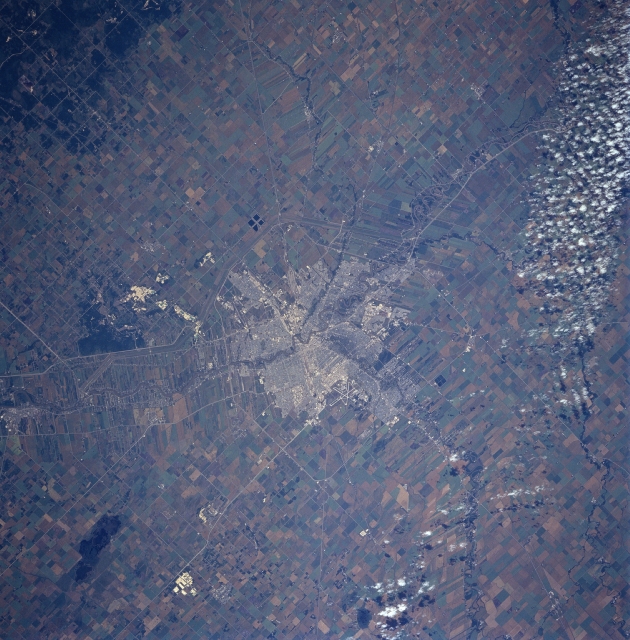 |
| STS085-750-004 Winnipeg, Manitoba, Canada August 1997 Winnipeg, the capitol of Manitoba with a population of over 600,000, stands out in dramatic fashion in comparison with the extensive agriculture in the surrounding rural landscape. Some street patterns are discernible within the city and several highways, such as the Perimeter Highway 101 are visible. Part of the Trans-Canada Highway #1 is also visible, as it extends generally east-west through downtown Winnipeg. Even the intersecting runways of Winnipeg International Airport in west Winnipeg can be seen. The easterly-flowing Assiniboine River merges with the northward-flowing Red River in downtown Winnipeg. The thin, elongated field patterns at right angles to the Red River show the influence of French ownership patterns carried over from Colonial days. Also see image and comments for STS059-226-012 for this same area. Agriculturally, most of the large fields produce wheat, as this region is part of the large Spring Wheat Belt of North America. A band of scattered clouds are visible along the southern edge of the picture. |
| Images: | All Available Images Low-Resolution 365k |
|
| Mission: | STS085 |
|
| Roll - Frame: | 750 - 4 |
|
| Geographical Name: | CANADA-M |
|
| Features: | WINNIPEG |
|
| Center Lat x Lon: | 50.0N x 97W |
|
| Film Exposure: | N | N=Normal exposure, U=Under exposed, O=Over exposed, F=out of Focus |
| Percentage of Cloud Cover-CLDP: | 5 |
|
| Camera:: | HB |
|
| Camera Tilt: | LO | LO=Low Oblique, HO=High Oblique, NV=Near Vertical |
| Camera Focal Length: | 250 |
|
| Nadir to Photo Center Direction: | The direction from the nadir to the center point, N=North, S=South, E=East, W=West |
|
| Stereo?: | Y | Y=Yes there is an adjacent picture of the same area, N=No there isn't |
| Orbit Number: | |
|
| Date: | 199708__ | YYYYMMDD |
| Time: | GMT HHMMSS |
|
| Nadir Lat: | N |
Latitude of suborbital point of spacecraft |
| Nadir Lon: | E |
Longitude of suborbital point of spacecraft |
| Sun Azimuth: | Clockwise angle in degrees from north to the sun measured at the nadir point |
|
| Space Craft Altitude: | nautical miles |
|
| Sun Elevation: | Angle in degrees between the horizon and the sun, measured at the nadir point |
|
| Land Views: | PLAIN |
|
| Water Views: | RIVER |
|
| Atmosphere Views: | |
|
| Man Made Views: | URBAN AREA, AGRICULTURE, HIGHWAY, AIRPORT |
|
| City Views: | |
|
Photo is not associated with any sequences | ||
| NASA Home Page |
JSC Home Page |
JSC Digital Image Collection |
Earth Science & Remote Sensing |
|
This service is provided by the International Space Station program and the JSC Earth Science & Remote Sensing Unit, ARES Division, Exploration Integration Science Directorate.

|