
Geographic Region: USA-NEW YORK
Feature: NEW YORK CITY,SHIP WAKES
|
Geographic Region: USA-NEW YORK Feature: NEW YORK CITY,SHIP WAKES |
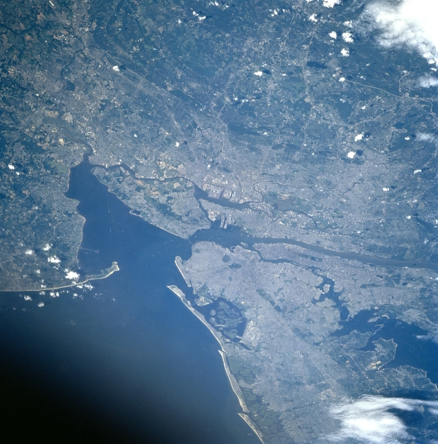 |
| STS085-738-051 Greater New York City Area, New York, USA August 1997 One of the world's largest population centers (exceeding 10 million in 1999) that includes metropolitan New York City (NY) and greater Newark (NJ) area is visible in this west-looking oblique view. Two prominent sandy features, Sandy Hook (NJ) and Rockaway Point (NY), partially enclose Lower Bay and separate it from the Atlantic Ocean. Staten Island is the large island northwest of Lower Bay. Immediately north of Lower Bay (and through The Narrows) the much smaller Upper Bay is visible. The southern end of the Hudson River flows into Upper Bay. A series of sandy barrier islands are visible along the south coast of Long Island. Jamaica Bay is the large enclosed bay with many islands due east from Brooklyn. The west end of Long Island Sound can be identified as the irregular shaped body of water along the north side of Long Island. |
| Images: | All Available Images Low-Resolution 362k |
|
| Mission: | STS085 |
|
| Roll - Frame: | 738 - 51 |
|
| Geographical Name: | USA-NEW YORK |
|
| Features: | NEW YORK CITY,SHIP WAKES |
|
| Center Lat x Lon: | 40.5N x 74W |
|
| Film Exposure: | N | N=Normal exposure, U=Under exposed, O=Over exposed, F=out of Focus |
| Percentage of Cloud Cover-CLDP: | 5 |
|
| Camera:: | HB |
|
| Camera Tilt: | LO | LO=Low Oblique, HO=High Oblique, NV=Near Vertical |
| Camera Focal Length: | 250 |
|
| Nadir to Photo Center Direction: | The direction from the nadir to the center point, N=North, S=South, E=East, W=West |
|
| Stereo?: | Y | Y=Yes there is an adjacent picture of the same area, N=No there isn't |
| Orbit Number: | |
|
| Date: | 199708__ | YYYYMMDD |
| Time: | GMT HHMMSS |
|
| Nadir Lat: | N |
Latitude of suborbital point of spacecraft |
| Nadir Lon: | E |
Longitude of suborbital point of spacecraft |
| Sun Azimuth: | Clockwise angle in degrees from north to the sun measured at the nadir point |
|
| Space Craft Altitude: | nautical miles |
|
| Sun Elevation: | Angle in degrees between the horizon and the sun, measured at the nadir point |
|
| Land Views: | ISLAND, COAST |
|
| Water Views: | BAY, RIVER |
|
| Atmosphere Views: | |
|
| Man Made Views: | |
|
| City Views: | |
|
Photo is not associated with any sequences | ||
| NASA Home Page |
JSC Home Page |
JSC Digital Image Collection |
Earth Science & Remote Sensing |
|
This service is provided by the International Space Station program and the JSC Earth Science & Remote Sensing Unit, ARES Division, Exploration Integration Science Directorate.

|