
Geographic Region: USA-WASHINGTON
Feature: COLUMBIA RIVER, MT. HOOD
|
Geographic Region: USA-WASHINGTON Feature: COLUMBIA RIVER, MT. HOOD |
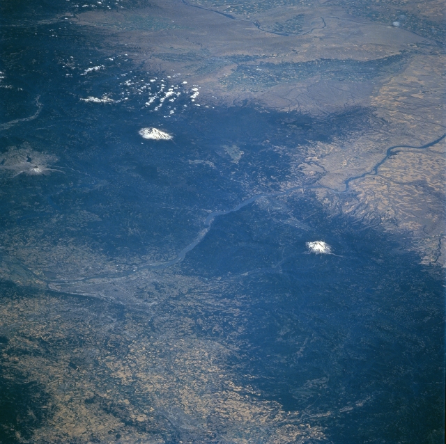 |
| STS085-734-085 Mt. Hood, Oregon and Mt. Adams, Washington, USA August 1997 The two most prominent features in this northeast looking view are the snow-capped summits of Mount Hood (OR) and Mount Adams (WA). At 11,239 feet (3426 meters) and 12325 feet (3757 meters), respectively, these two volcanoes are part of the north-trending Cascade Range. The Cascades provide a formidable meteorological barrier that dramatically reduces precipitation amounts on the leeward or eastern side of the mountains. This rain shadow effect limits farming on the eastern side of the mountains to plateaus and river valleys where adequate supplies of moisture are available. Notice that there are some clusters of cultivated fields in the Yakima and Columbia River Valleys. The Columbia River, (center of view) flows west through the Cascade Mountains. The river forms the boundary between the states of Oregon and Washington. Although not easy to recognize, the city of Portland (OR) can be located along the south side of the Columbia River near the west edge of the picture. South of Portland the fertile northern Willamette River Valley with its multitude of cultivated fields are visible (lighter colors intermixed with darker colors). Mt. St. Helens and its denuded, "blast" zone from the 1980 eruption are also discernible along the western edge of the image north of the Columbia River. |
| Images: | All Available Images Low-Resolution 353k |
|
| Mission: | STS085 |
|
| Roll - Frame: | 734 - 85 |
|
| Geographical Name: | USA-WASHINGTON |
|
| Features: | COLUMBIA RIVER, MT. HOOD |
|
| Center Lat x Lon: | 45.5N x 122W |
|
| Film Exposure: | N | N=Normal exposure, U=Under exposed, O=Over exposed, F=out of Focus |
| Percentage of Cloud Cover-CLDP: | 5 |
|
| Camera:: | HB |
|
| Camera Tilt: | LO | LO=Low Oblique, HO=High Oblique, NV=Near Vertical |
| Camera Focal Length: | 100 |
|
| Nadir to Photo Center Direction: | NE | The direction from the nadir to the center point, N=North, S=South, E=East, W=West |
| Stereo?: | Y | Y=Yes there is an adjacent picture of the same area, N=No there isn't |
| Orbit Number: | 35 |
|
| Date: | 19970809 | YYYYMMDD |
| Time: | 180338 | GMT HHMMSS |
| Nadir Lat: | 41.8N |
Latitude of suborbital point of spacecraft |
| Nadir Lon: | 127.2W |
Longitude of suborbital point of spacecraft |
| Sun Azimuth: | 117 | Clockwise angle in degrees from north to the sun measured at the nadir point |
| Space Craft Altitude: | 158 | nautical miles |
| Sun Elevation: | 49 | Angle in degrees between the horizon and the sun, measured at the nadir point |
| Land Views: | VOLCANO, MOUNTAIN |
|
| Water Views: | RIVER |
|
| Atmosphere Views: | |
|
| Man Made Views: | AGRICULTURE |
|
| City Views: | |
|
Photo is not associated with any sequences | ||
| NASA Home Page |
JSC Home Page |
JSC Digital Image Collection |
Earth Science & Remote Sensing |
|
This service is provided by the International Space Station program and the JSC Earth Science & Remote Sensing Unit, ARES Division, Exploration Integration Science Directorate.

|