Geographic Region: GREENLAND
Feature: PRINS CHRISTIANS SOUND
|
Geographic Region: GREENLAND Feature: PRINS CHRISTIANS SOUND |
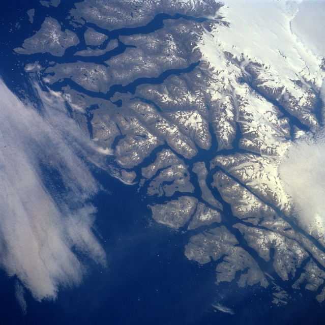 |
| STS085-729-053 Southern Coast, Greenland August 1997 Although the viewing angle (look direction) and the geographic area included in this image are different from STS85-713-074, both of these pictures show the southern tip of Greenland from slightly different prospectives. This particular image shows more of the southwestern tip with its extensively fjorded coastline. The large area of white in the upper right corner of the picture is part of a large, permanent ice field that extends southward through the mountainous area of southern Greenland. This summertime view of the rugged fjorded coastline shows an exposed landscape where a variety of flora (forest-like brush species) grows on the mountain slopes, isolated marshes, and alpine meadows. Two separate cloud patterns (whitish areas) are observed: one along the right edge (middle) and the other along the left edge (center) of the picture. |
| Images: | All Available Images Low-Resolution 344k |
|
| Mission: | STS085 |
|
| Roll - Frame: | 729 - 53 |
|
| Geographical Name: | GREENLAND |
|
| Features: | PRINS CHRISTIANS SOUND |
|
| Center Lat x Lon: | 60.0N x 44W |
|
| Film Exposure: | N | N=Normal exposure, U=Under exposed, O=Over exposed, F=out of Focus |
| Percentage of Cloud Cover-CLDP: | 30 |
|
| Camera:: | HB |
|
| Camera Tilt: | 53 | LO=Low Oblique, HO=High Oblique, NV=Near Vertical |
| Camera Focal Length: | 100 |
|
| Nadir to Photo Center Direction: | NE | The direction from the nadir to the center point, N=North, S=South, E=East, W=West |
| Stereo?: | Y | Y=Yes there is an adjacent picture of the same area, N=No there isn't |
| Orbit Number: | 65 |
|
| Date: | 19970811 | YYYYMMDD |
| Time: | 152320 | GMT HHMMSS |
| Nadir Lat: | 57.1N |
Latitude of suborbital point of spacecraft |
| Nadir Lon: | 45.8W |
Longitude of suborbital point of spacecraft |
| Sun Azimuth: | 185 | Clockwise angle in degrees from north to the sun measured at the nadir point |
| Space Craft Altitude: | 157 | nautical miles |
| Sun Elevation: | 48 | Angle in degrees between the horizon and the sun, measured at the nadir point |
| Land Views: | VALLEY |
|
| Water Views: | ESTUARY |
|
| Atmosphere Views: | |
|
| Man Made Views: | |
|
| City Views: | |
|
Photo is not associated with any sequences | ||
| NASA Home Page |
JSC Home Page |
JSC Digital Image Collection |
Earth Science & Remote Sensing |
|
This service is provided by the International Space Station program and the JSC Earth Science & Remote Sensing Unit, ARES Division, Exploration Integration Science Directorate.

|