Geographic Region: DENMARK
Feature: BORNHOLM
|
Geographic Region: DENMARK Feature: BORNHOLM |
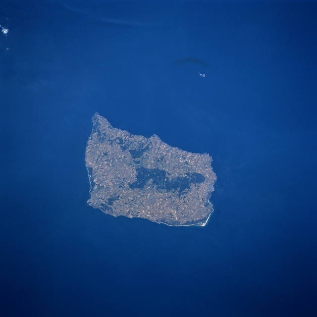 |
| STS085-721-064 Bornholm Island, Denmark August 1997 Located in the Baltic Sea between Sweden and Poland, Bornholm Island is the easternmost and smallest county of Denmark. Although relatively small in size (226 square miles-587 square km), this Danish island offers a variety of scenic landforms and land use activities that includes sandy beaches, rocky cliffs, forests (mainly darker areas near the center of the island), and an extensive area of cultivated field patterns (lighter colored terrain). Because of the moderating influence of the Baltic Sea, Bornholm has a relatively mild climate in comparison with the Scandinavian countries north of the island. As a result of the moderate temperatures and the scenic beauty of the island, tourism has become one of the major economic activities for islanders since World War II. The small islands of Christians and Frederiks, which are controlled by the Danish Ministry of Defense, are visible as light colored features northeast of Bornholm Island. |
| Images: | All Available Images Low-Resolution 235k |
|
| Mission: | STS085 |
|
| Roll - Frame: | 721 - 64 |
|
| Geographical Name: | DENMARK |
|
| Features: | BORNHOLM |
|
| Center Lat x Lon: | 55.0N x 15.0E |
|
| Film Exposure: | N | N=Normal exposure, U=Under exposed, O=Over exposed, F=out of Focus |
| Percentage of Cloud Cover-CLDP: | 0 |
|
| Camera:: | HB |
|
| Camera Tilt: | 26 | LO=Low Oblique, HO=High Oblique, NV=Near Vertical |
| Camera Focal Length: | 250 |
|
| Nadir to Photo Center Direction: | NW | The direction from the nadir to the center point, N=North, S=South, E=East, W=West |
| Stereo?: | Y | Y=Yes there is an adjacent picture of the same area, N=No there isn't |
| Orbit Number: | 95 |
|
| Date: | 19970813 | YYYYMMDD |
| Time: | 123718 | GMT HHMMSS |
| Nadir Lat: | 53.9N |
Latitude of suborbital point of spacecraft |
| Nadir Lon: | 15.6E |
Longitude of suborbital point of spacecraft |
| Sun Azimuth: | 215 | Clockwise angle in degrees from north to the sun measured at the nadir point |
| Space Craft Altitude: | 156 | nautical miles |
| Sun Elevation: | 47 | Angle in degrees between the horizon and the sun, measured at the nadir point |
| Land Views: | ISLAND |
|
| Water Views: | SEA |
|
| Atmosphere Views: | |
|
| Man Made Views: | |
|
| City Views: | |
|
Photo is not associated with any sequences | ||
| NASA Home Page |
JSC Home Page |
JSC Digital Image Collection |
Earth Science & Remote Sensing |
|
This service is provided by the International Space Station program and the JSC Earth Science & Remote Sensing Unit, ARES Division, Exploration Integration Science Directorate.

|