
Geographic Region: USA-MICHIGAN
Feature: MARQUETTE
|
Geographic Region: USA-MICHIGAN Feature: MARQUETTE |
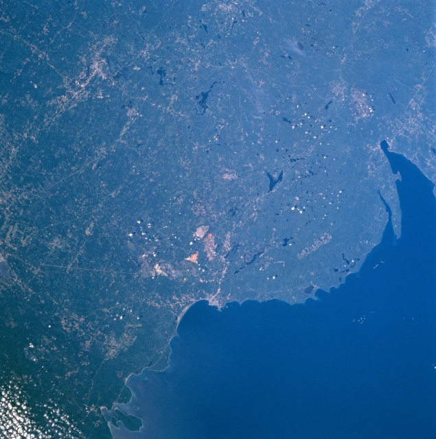 |
| STS085-716-009 Huron Mountains, Marquette, Michigan August, 1997 The forested Huron Mountains lie between Keeweenaw Bay and Marquette, Michigan in this southwest-looking low-oblique view. Extensive mining of iron ore and marble plus lumbering are major industries in this region. With the dense forests of pine and deciduous trees, the region is also a recreational area year around. Lake Superior, one of the largest lakes in the world covers the upper left portion of the image. Near the center of the image, open-pit mines and quarries can be seen. Northeast of the quarries along the shore of Lake Superior is the city of Marquette, the largest city in the Upper Peninsula. The city has docks and facilities to transport iron ore by ship to steel mills in Indiana, Ohio, and Pennsylvania. Marquette is also the home of the United States Olympic Education Center at Northern Michigan University where athletes train for the Winter Olympic Games. Near the upper right of the image is Grand Island, a National Recreation Area. |
| Images: | All Available Images Low-Resolution 346k |
|
| Mission: | STS085 |
|
| Roll - Frame: | 716 - 9 |
|
| Geographical Name: | USA-MICHIGAN |
|
| Features: | MARQUETTE |
|
| Center Lat x Lon: | 46.5N x 87.5W |
|
| Film Exposure: | N | N=Normal exposure, U=Under exposed, O=Over exposed, F=out of Focus |
| Percentage of Cloud Cover-CLDP: | 5 |
|
| Camera:: | HB |
|
| Camera Tilt: | 25 | LO=Low Oblique, HO=High Oblique, NV=Near Vertical |
| Camera Focal Length: | 100 |
|
| Nadir to Photo Center Direction: | E | The direction from the nadir to the center point, N=North, S=South, E=East, W=West |
| Stereo?: | Y | Y=Yes there is an adjacent picture of the same area, N=No there isn't |
| Orbit Number: | 65 |
|
| Date: | 19970811 | YYYYMMDD |
| Time: | 151559 | GMT HHMMSS |
| Nadir Lat: | 46.3N |
Latitude of suborbital point of spacecraft |
| Nadir Lon: | 88.7W |
Longitude of suborbital point of spacecraft |
| Sun Azimuth: | 118 | Clockwise angle in degrees from north to the sun measured at the nadir point |
| Space Craft Altitude: | 156 | nautical miles |
| Sun Elevation: | 44 | Angle in degrees between the horizon and the sun, measured at the nadir point |
| Land Views: | PENINSULA, HILL, FOREST |
|
| Water Views: | LAKE |
|
| Atmosphere Views: | |
|
| Man Made Views: | MINING |
|
| City Views: | |
|
Photo is not associated with any sequences | ||
| NASA Home Page |
JSC Home Page |
JSC Digital Image Collection |
Earth Science & Remote Sensing |
|
This service is provided by the International Space Station program and the JSC Earth Science & Remote Sensing Unit, ARES Division, Exploration Integration Science Directorate.

|