
Geographic Region: CANADA-BC
Feature: PAN-VANCOUVER
|
Geographic Region: CANADA-BC Feature: PAN-VANCOUVER |
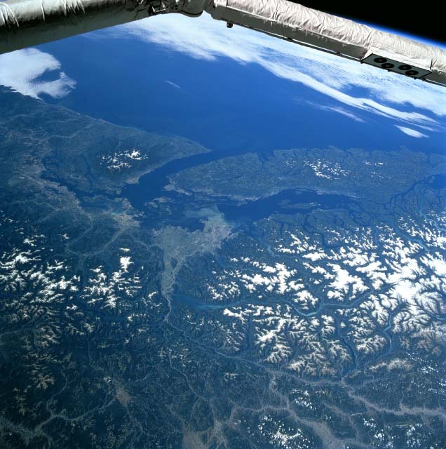 |
| STS085-715-033 Fraser River Valley, British Columbia, Canada August 1997 The Fraser River Valley and its extensive delta (light colored feature) can be observed near the center of the image. A light colored sediment plume can be observed west of Vancouver where the Fraser River empties into the Strait of Georgia (center of picture). The Strait of Georgia separates Vancouver Island from the mainland of British Columbia (Canada). The Juan De Fuca Strait is the other major strait that connects Pudget Sound (U.S.) and the Strait of Georgia with the partially cloud-covered Pacific Ocean (top). Extensive forested slopes and snow covered higher elevations of the Coast Mountains in British Columbia and the northern Cascades in the state of Washington occupy about a third of the picture. There are also limited snow covered peaks in the Olympic Mountains of northwest Washington (top left) and on the central mountains of Vancouver Island, B. C. (top right). A section of the Space Shuttle robotic arm crosses the top of the image. |
| Images: | All Available Images Low-Resolution 85k |
|
| Mission: | STS085 |
|
| Roll - Frame: | 715 - 33 |
|
| Geographical Name: | CANADA-BC |
|
| Features: | PAN-VANCOUVER |
|
| Center Lat x Lon: | 49.0N x 123W |
|
| Film Exposure: | N | N=Normal exposure, U=Under exposed, O=Over exposed, F=out of Focus |
| Percentage of Cloud Cover-CLDP: | 10 |
|
| Camera:: | HB |
|
| Camera Tilt: | HO | LO=Low Oblique, HO=High Oblique, NV=Near Vertical |
| Camera Focal Length: | 100 |
|
| Nadir to Photo Center Direction: | NE | The direction from the nadir to the center point, N=North, S=South, E=East, W=West |
| Stereo?: | Y | Y=Yes there is an adjacent picture of the same area, N=No there isn't |
| Orbit Number: | 67 |
|
| Date: | 19970811 | YYYYMMDD |
| Time: | 181250 | GMT HHMMSS |
| Nadir Lat: | 36.0N |
Latitude of suborbital point of spacecraft |
| Nadir Lon: | 148.1W |
Longitude of suborbital point of spacecraft |
| Sun Azimuth: | 97 | Clockwise angle in degrees from north to the sun measured at the nadir point |
| Space Craft Altitude: | 156 | nautical miles |
| Sun Elevation: | 36 | Angle in degrees between the horizon and the sun, measured at the nadir point |
| Land Views: | MOUNTAIN, ISLAND |
|
| Water Views: | RIVER, STRAIT, DELTA |
|
| Atmosphere Views: | |
|
| Man Made Views: | |
|
| City Views: | |
|
Photo is not associated with any sequences | ||
| NASA Home Page |
JSC Home Page |
JSC Digital Image Collection |
Earth Science & Remote Sensing |
|
This service is provided by the International Space Station program and the JSC Earth Science & Remote Sensing Unit, ARES Division, Exploration Integration Science Directorate.

|