Geographic Region: GREENLAND
Feature: ICEBERGS
|
Geographic Region: GREENLAND Feature: ICEBERGS |
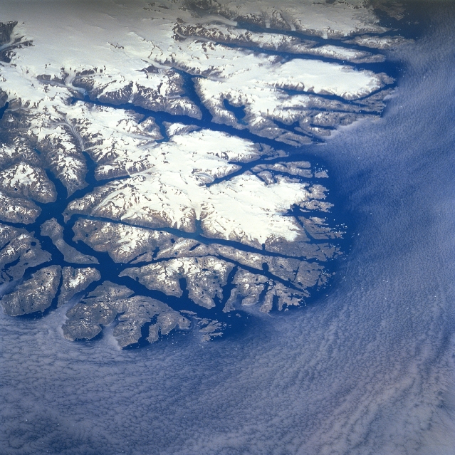 |
| STS085-713-074 Fjorded Coastline, Greenland (Denmark) August 1997 This low oblique, northeast view of the south, southeast tip of Greenland shows the glaciated coastline of the world's largest island. The elongated, dark fingers of the open water from the North Atlantic Ocean that extend towards the interior are fjords. These deep, glacial troughs along the coastline are eroded valleys that once were occupied by valley glaciers. Several valley glaciers can be seen at the head of some of the fjords. The large concentrations of white on the image show the location of the prominent ice fields. The elevated ice fields shown on this image are located between 60 and 61 degrees north latitude. |
| Images: | All Available Images Low-Resolution 381k |
|
| Mission: | STS085 |
|
| Roll - Frame: | 713 - 74 |
|
| Geographical Name: | GREENLAND |
|
| Features: | ICEBERGS |
|
| Center Lat x Lon: | 61.0N x 44.5W |
|
| Film Exposure: | N | N=Normal exposure, U=Under exposed, O=Over exposed, F=out of Focus |
| Percentage of Cloud Cover-CLDP: | 40 |
|
| Camera:: | HB |
|
| Camera Tilt: | LO | LO=Low Oblique, HO=High Oblique, NV=Near Vertical |
| Camera Focal Length: | 100 |
|
| Nadir to Photo Center Direction: | N | The direction from the nadir to the center point, N=North, S=South, E=East, W=West |
| Stereo?: | Y | Y=Yes there is an adjacent picture of the same area, N=No there isn't |
| Orbit Number: | 81 |
|
| Date: | 19970812 | YYYYMMDD |
| Time: | 152947 | GMT HHMMSS |
| Nadir Lat: | 57.0N |
Latitude of suborbital point of spacecraft |
| Nadir Lon: | 43.8W |
Longitude of suborbital point of spacecraft |
| Sun Azimuth: | 191 | Clockwise angle in degrees from north to the sun measured at the nadir point |
| Space Craft Altitude: | 156 | nautical miles |
| Sun Elevation: | 48 | Angle in degrees between the horizon and the sun, measured at the nadir point |
| Land Views: | VALLEY |
|
| Water Views: | ESTUARY |
|
| Atmosphere Views: | |
|
| Man Made Views: | |
|
| City Views: | |
|
Photo is not associated with any sequences | ||
| NASA Home Page |
JSC Home Page |
JSC Digital Image Collection |
Earth Science & Remote Sensing |
|
This service is provided by the International Space Station program and the JSC Earth Science & Remote Sensing Unit, ARES Division, Exploration Integration Science Directorate.

|