
Geographic Region: USA-SOUTH DAKOTA
Feature: OAHE RESERVOIR
|
Geographic Region: USA-SOUTH DAKOTA Feature: OAHE RESERVOIR |
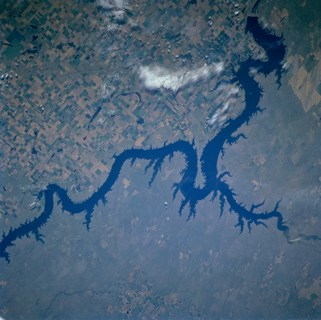 |
| STS085-713-058 Oahe Reservoir, South Dakota August, 1997 The fourth largest in the United States, the Oahe Reservoir can be seen in this southwest-looking low-oblique view. Located on the Missouri River 5 miles (8 km) north of Pierre, South Dakota, the Oahe Reservoir stretches 231 miles (371 km) northward to just south of Bismarck, North Dakota (not visible on the image). The Oahe Dam is the second largest earthfill structure of its kind in the world. The lake has nearly 2250 miles (3523 km) of shoreline and is a very popular recreational area known for its excellent fishing. The dam also provides flood control, hydroelectric power, and irrigation. Numerous agricultural field patterns can be seen to the east of the reservoir. The Cheyenne River enters the scene near the upper right of the image and it joins Oahe Reservoir near the Fort Sully Game Refuge (peninsula jutting out into lake). |
| Images: | Images: | NO IMAGES YET | |||
| Mission: | STS085 |
||||
| Roll - Frame: | 713 - 58 |
||||
| Geographical Name: | USA-SOUTH DAKOTA |
||||
| Features: | OAHE RESERVOIR |
||||
| Center Lat x Lon: | 45.0N x 100.5W |
||||
| Film Exposure: | N | N=Normal exposure, U=Under exposed, O=Over exposed, F=out of Focus |
|||
| Percentage of Cloud Cover-CLDP: | 5 |
||||
| Camera:: | HB |
||||
| Camera Tilt: | 45 | LO=Low Oblique, HO=High Oblique, NV=Near Vertical |
|||
| Camera Focal Length: | 100 |
||||
| Nadir to Photo Center Direction: | W | The direction from the nadir to the center point, N=North, S=South, E=East, W=West |
|||
| Stereo?: | Y | Y=Yes there is an adjacent picture of the same area, N=No there isn't |
|||
| Orbit Number: | 81 |
||||
| Date: | 19970812 | YYYYMMDD |
|||
| Time: | 152038 | GMT HHMMSS |
|||
| Nadir Lat: | 44.9N |
Latitude of suborbital point of spacecraft | |||
| Nadir Lon: | 97.9W |
Longitude of suborbital point of spacecraft | |||
| Sun Azimuth: | 110 | Clockwise angle in degrees from north to the sun measured at the nadir point |
|||
| Space Craft Altitude: | 155 | nautical miles |
|||
| Sun Elevation: | 39 | Angle in degrees between the horizon and the sun, measured at the nadir point |
|||
| Land Views: | PLAIN |
||||
| Water Views: | LAKE, RIVER |
||||
| Atmosphere Views: | |
||||
| Man Made Views: | AGRICULTURE |
||||
| City Views: | |
||||
Photo is not associated with any sequences | |||||
| NASA Home Page |
JSC Home Page |
JSC Digital Image Collection |
Earth Science & Remote Sensing |
|
This service is provided by the International Space Station program and the JSC Earth Science & Remote Sensing Unit, ARES Division, Exploration Integration Science Directorate.

|