
Geographic Region: KAZAKHSTAN
Feature: PAN-ARAL SEA
|
Geographic Region: KAZAKHSTAN Feature: PAN-ARAL SEA |
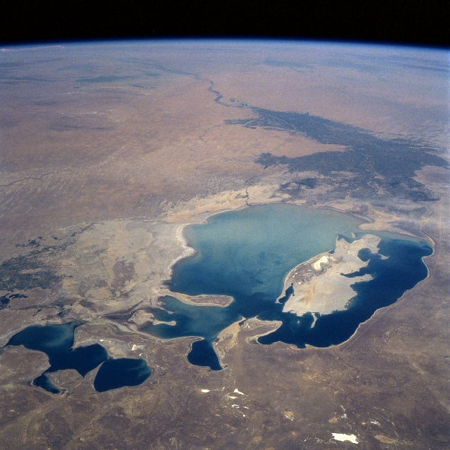 |
| STS085-711-078 Aral Sea, Kazakhstan/Uzbekistan August 1997 Once the world's fourth largest lake, the Aral Sea, now the world's eight largest lake, can be seen in this southeast-looking view. The Aral Sea sits in a basin surrounded by the arid Ustyurt Plateau to the west (bottom right), the Kara Sandy Desert to the south (upper right), the Kyzyl Sandy Desert to the east (center left and upper left), and the Aral Mangy Desert to the north (bottom left). Two rivers originally fed the Aral Sea, the Syr Darya from the east (left center) and the Amu Darya from the south (right center to upper right). The former Soviet Union began irrigating vast areas along both rivers in the early 1950's for cotton production. Hugh volumes of water were diverted causing the rivers to sometimes run dry by the time they reached the Aral Sea. Already situated in a semi-arid location, surface evaporation from the Aral Sea began to accelerate and the sea began to shrink. It is estimated that the Aral Sea lost over 40 percent of its surface area between 1960 and 1995. In some areas of the sea, the present shoreline lies 50 miles (81 km) or more from its former shores. The waters of the sea have increased in salinity and a large fishing industry has collapsed. Millions of people in the area are affected by the winds carrying salt, sand, and mineral particles from the former lakebed. The severe health hazards include high rates of throat cancer, eye disease, respiratory problems, and infant mortality. Though little can be done to save the Aral Sea, it could eventually shrink to a tenth of its former size. Scientists have stated that the Aral Sea problem is one of the five greatest environmental disasters of the Twentieth Century. |
| Images: | Images: | NO IMAGES YET | |||
| Mission: | STS085 |
||||
| Roll - Frame: | 711 - 78 |
||||
| Geographical Name: | KAZAKHSTAN |
||||
| Features: | PAN-ARAL SEA |
||||
| Center Lat x Lon: | 45.0N x 60.0E |
||||
| Film Exposure: | N | N=Normal exposure, U=Under exposed, O=Over exposed, F=out of Focus |
|||
| Percentage of Cloud Cover-CLDP: | 0 |
||||
| Camera:: | HB |
||||
| Camera Tilt: | HO | LO=Low Oblique, HO=High Oblique, NV=Near Vertical |
|||
| Camera Focal Length: | 100 |
||||
| Nadir to Photo Center Direction: | S | The direction from the nadir to the center point, N=North, S=South, E=East, W=West |
|||
| Stereo?: | Y | Y=Yes there is an adjacent picture of the same area, N=No there isn't |
|||
| Orbit Number: | 78 |
||||
| Date: | 19970812 | YYYYMMDD |
|||
| Time: | 110412 | GMT HHMMSS |
|||
| Nadir Lat: | 49.6N |
Latitude of suborbital point of spacecraft | |||
| Nadir Lon: | 57.7E |
Longitude of suborbital point of spacecraft | |||
| Sun Azimuth: | 240 | Clockwise angle in degrees from north to the sun measured at the nadir point |
|||
| Space Craft Altitude: | 157 | nautical miles |
|||
| Sun Elevation: | 41 | Angle in degrees between the horizon and the sun, measured at the nadir point |
|||
| Land Views: | DESERT, ISLAND |
||||
| Water Views: | LAKE, RIVER |
||||
| Atmosphere Views: | |
||||
| Man Made Views: | AGRICULTURE |
||||
| City Views: | |
||||
Photo is not associated with any sequences | |||||
| NASA Home Page |
JSC Home Page |
JSC Digital Image Collection |
Earth Science & Remote Sensing |
|
This service is provided by the International Space Station program and the JSC Earth Science & Remote Sensing Unit, ARES Division, Exploration Integration Science Directorate.

|