
Geographic Region: USA-NEVADA
Feature: RENO
|
Geographic Region: USA-NEVADA Feature: RENO |
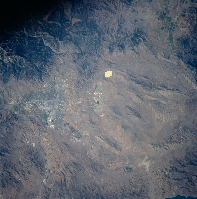 |
| STS085-710-16 Reno, Nevada August, 1997 Situated midway between the center and upper center of the image, the cities of Reno and Sparks, Nevada are visible in this near-vertical view. Located on the Truckee River near the Sierra Nevada, Reno is the second largest city in the state. It produces lumber, cement, electronic components, and is a trade and distribution center for livestock and grain. Reno is an important tourist center in the middle of a vast recreation area, including numerous gambling casinos. The site on which Reno is now located was a popular campsite on the Donner Pass route, across the Sierra Nevada (upper right of the image) to California. The city of Sparks is located just to the east of Reno. Near the center of the image and to the north of Reno are salt-pans and playa-type dry lakes. |
| Images: | All Available Images Low-Resolution 343k |
|
| Mission: | STS085 |
|
| Roll - Frame: | 710 - 16 |
|
| Geographical Name: | USA-NEVADA |
|
| Features: | RENO |
|
| Center Lat x Lon: | 39.5N x 120W |
|
| Film Exposure: | N | N=Normal exposure, U=Under exposed, O=Over exposed, F=out of Focus |
| Percentage of Cloud Cover-CLDP: | 0 |
|
| Camera:: | HB |
|
| Camera Tilt: | 18 | LO=Low Oblique, HO=High Oblique, NV=Near Vertical |
| Camera Focal Length: | 100 |
|
| Nadir to Photo Center Direction: | S | The direction from the nadir to the center point, N=North, S=South, E=East, W=West |
| Stereo?: | Y | Y=Yes there is an adjacent picture of the same area, N=No there isn't |
| Orbit Number: | 66 |
|
| Date: | 19970811 | YYYYMMDD |
| Time: | 164358 | GMT HHMMSS |
| Nadir Lat: | 40.3N |
Latitude of suborbital point of spacecraft |
| Nadir Lon: | 120.3W |
Longitude of suborbital point of spacecraft |
| Sun Azimuth: | 105 | Clockwise angle in degrees from north to the sun measured at the nadir point |
| Space Craft Altitude: | 156 | nautical miles |
| Sun Elevation: | 40 | Angle in degrees between the horizon and the sun, measured at the nadir point |
| Land Views: | MOUNTAIN, PLATEAU |
|
| Water Views: | LAKE |
|
| Atmosphere Views: | |
|
| Man Made Views: | URBAN AREA, PIVOT IRRIGATION |
|
| City Views: | RENO, SPARKS |
|
Photo is not associated with any sequences | ||
| NASA Home Page |
JSC Home Page |
JSC Digital Image Collection |
Earth Science & Remote Sensing |
|
This service is provided by the International Space Station program and the JSC Earth Science & Remote Sensing Unit, ARES Division, Exploration Integration Science Directorate.

|