 Photo #: STS085-709-17 Date: Aug. 1997
Geographic Region: USA-HAWAII
Feature: HAWAII

 Photo #: STS085-709-17 Date: Aug. 1997 Photo #: STS085-709-17 Date: Aug. 1997Geographic Region: USA-HAWAII Feature: HAWAII |
 |
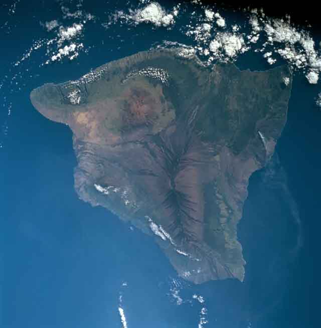
| STS085-709-017 The Island of Hawaii, Hawaiian Island Chain August, 1997 Hawaii, geologically the youngest of the Hawaiian Islands, can be seen in this near-vertical view. The Big Island is as large as all the other Hawaiian Islands combined. It covers an area the size of the state of Connecticut, spanning 90 miles (144 km) from north to south, and 80 miles (129 km) from east to west. Five large volcanoes coalesce to make the visible part of Hawaii; a sixth lies beneath the sea off the south-southeast coast (Loihi). The southern part of the island is still volcanically active (Mauna Loa and Kilauea), while the northern part of the island is in the waning stages of activity (Mauna Kea, Hualalai, and Kohala). Near the center of the image, Mauna Loa can be seen. Kilauea, southeast of Mauna Loa, is the most active and youngest volcano. Mauna Kea to the north of Mauna Loa is the highest of the Hawaiian volcanoes and from its base to its summit is over 33000 feet (10650 meters) in elevation. To the left (northwest) on the image from Mauna Loa and barely discernible due to some clouds is Hualalai, the third oldest volcano on the Big Island. It is located on the central Kona Coast. Kohala is the big Island's oldest volcano and it forms a large peninsula extending north from Mauna Kea. |
| Images: | All Available Images Low-Resolution 27k |
|
| Mission: | STS085 |
|
| Roll - Frame: | 709 - 17 |
|
| Geographical Name: | USA-HAWAII |
|
| Features: | HAWAII |
|
| Center Lat x Lon: | 19.5N x 155.5W |
|
| Film Exposure: | N | N=Normal exposure, U=Under exposed, O=Over exposed, F=out of Focus |
| Percentage of Cloud Cover-CLDP: | 15 |
|
| Camera:: | HB |
|
| Camera Tilt: | 21 | LO=Low Oblique, HO=High Oblique, NV=Near Vertical |
| Camera Focal Length: | 100 |
|
| Nadir to Photo Center Direction: | W | The direction from the nadir to the center point, N=North, S=South, E=East, W=West |
| Stereo?: | Y | Y=Yes there is an adjacent picture of the same area, N=No there isn't |
| Orbit Number: | 51 |
|
| Date: | 19970810 | YYYYMMDD |
| Time: | 180203 | GMT HHMMSS |
| Nadir Lat: | 19.5N |
Latitude of suborbital point of spacecraft |
| Nadir Lon: | 154.5W |
Longitude of suborbital point of spacecraft |
| Sun Azimuth: | 82 | Clockwise angle in degrees from north to the sun measured at the nadir point |
| Space Craft Altitude: | 157 | nautical miles |
| Sun Elevation: | 28 | Angle in degrees between the horizon and the sun, measured at the nadir point |
| Land Views: | VOLCANO, CALDERA, COAST, RIFT |
|
| Water Views: | |
|
| Atmosphere Views: | SMOKE |
|
| Man Made Views: | |
|
| City Views: | |
|
Photo is not associated with any sequences | ||
| NASA Home Page |
JSC Home Page |
JSC Digital Image Collection |
Earth Science & Remote Sensing |
|
|