
Geographic Region: USA-TEXAS
Feature: ABILENE
|
Geographic Region: USA-TEXAS Feature: ABILENE |
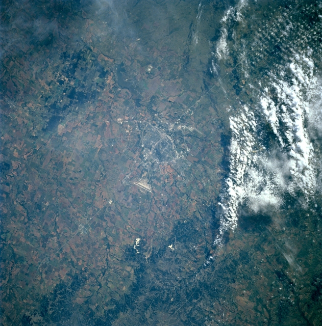 |
| STS085-708-068 Abilene, Texas August, 1997 This southeast-looking view shows the city of Abilene, Texas. Abilene grew as a shipping point for cattle ranches and is now the financial, commercial, and educational center of a large part of west Texas. The city has a diversified economy, which includes manufacturing, retail trade, farming and ranching, and petroleum. Abilene is the home of Dyess Air Force Base, the major runway for which is visible just to the right of the center of the image (west of the city). The runways of Abilene Regional Airport are discernible to the southeast of the city (step-like pair of light lines). Barely discernible to the north of the city is a small reservoir. |
| Images: | All Available Images Low-Resolution 382k |
|
| Mission: | STS085 |
|
| Roll - Frame: | 708 - 68 |
|
| Geographical Name: | USA-TEXAS |
|
| Features: | ABILENE |
|
| Center Lat x Lon: | 32.5N x 99.5W |
|
| Film Exposure: | N | N=Normal exposure, U=Under exposed, O=Over exposed, F=out of Focus |
| Percentage of Cloud Cover-CLDP: | 20 |
|
| Camera:: | HB |
|
| Camera Tilt: | 27 | LO=Low Oblique, HO=High Oblique, NV=Near Vertical |
| Camera Focal Length: | 100 |
|
| Nadir to Photo Center Direction: | N | The direction from the nadir to the center point, N=North, S=South, E=East, W=West |
| Stereo?: | Y | Y=Yes there is an adjacent picture of the same area, N=No there isn't |
| Orbit Number: | 49 |
|
| Date: | 19970810 | YYYYMMDD |
| Time: | 150506 | GMT HHMMSS |
| Nadir Lat: | 31.2N |
Latitude of suborbital point of spacecraft |
| Nadir Lon: | 99.7W |
Longitude of suborbital point of spacecraft |
| Sun Azimuth: | 94 | Clockwise angle in degrees from north to the sun measured at the nadir point |
| Space Craft Altitude: | 157 | nautical miles |
| Sun Elevation: | 38 | Angle in degrees between the horizon and the sun, measured at the nadir point |
| Land Views: | PLATEAU, ESCARPMENT |
|
| Water Views: | |
|
| Atmosphere Views: | |
|
| Man Made Views: | URBAN AREA, AIRPORT, HIGHWAY |
|
| City Views: | ABILENE |
|
Photo is not associated with any sequences | ||
| NASA Home Page |
JSC Home Page |
JSC Digital Image Collection |
Earth Science & Remote Sensing |
|
This service is provided by the International Space Station program and the JSC Earth Science & Remote Sensing Unit, ARES Division, Exploration Integration Science Directorate.

|