Geographic Region: CANADA-A
Feature: CALGARY
|
Geographic Region: CANADA-A Feature: CALGARY |
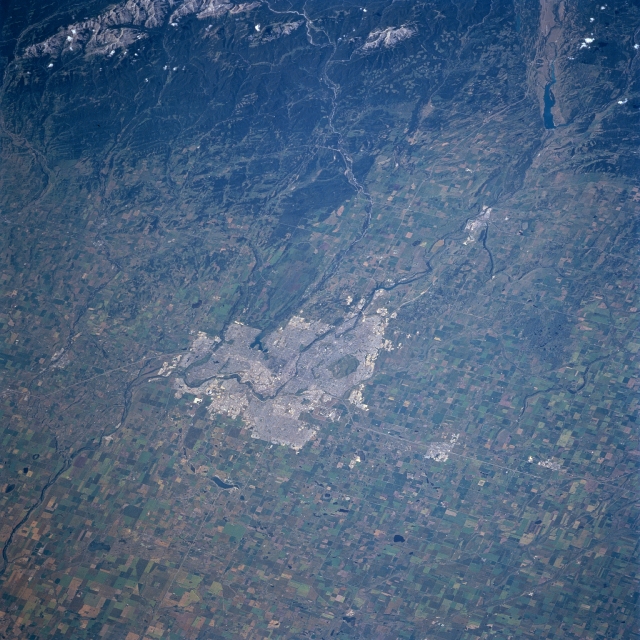 |
| STS085-707-061 Calgary, Alberta, Canada August 1997 This westerly looking view of Calgary and its environs provides a unique opportunity to look at the details of the urban region and the physical setting of this dynamic Canadian city. The large gray, rectangular region in the middle of the image is the city of Calgary. It is expanding northward, evidenced by the commuter city of Airdrie (the light area north of Calgary along Highway 2). Within the city is a darker, oval-shaped park, Nose Hill. West of Calgary, two rivers (the Bow and the Elbow Rivers) that have their headwaters in the Canadian Rocky Mountains flow generally eastward and then merge in south Calgary to become just the Bow River. The dark areas of the Rocky Mountains show forested slopes. The patchwork of lighter-colored sites in the forest between the two rivers shows sizable areas of forest clear cuts. The hilly landscape west of Calgary is used primarily as prairie ranch lands, while the extensive agricultural lands east of the city are used for growing wheat and other cereal grains. |
| Images: | All Available Images Low-Resolution 372k |
|
| Mission: | STS085 |
|
| Roll - Frame: | 707 - 61 |
|
| Geographical Name: | CANADA-A |
|
| Features: | CALGARY |
|
| Center Lat x Lon: | 51.0N x 114W |
|
| Film Exposure: | N | N=Normal exposure, U=Under exposed, O=Over exposed, F=out of Focus |
| Percentage of Cloud Cover-CLDP: | 0 |
|
| Camera:: | HB |
|
| Camera Tilt: | 42 | LO=Low Oblique, HO=High Oblique, NV=Near Vertical |
| Camera Focal Length: | 100 |
|
| Nadir to Photo Center Direction: | SW | The direction from the nadir to the center point, N=North, S=South, E=East, W=West |
| Stereo?: | Y | Y=Yes there is an adjacent picture of the same area, N=No there isn't |
| Orbit Number: | 51 |
|
| Date: | 19970810 | YYYYMMDD |
| Time: | 181409 | GMT HHMMSS |
| Nadir Lat: | 52.8N |
Latitude of suborbital point of spacecraft |
| Nadir Lon: | 112.5W |
Longitude of suborbital point of spacecraft |
| Sun Azimuth: | 149 | Clockwise angle in degrees from north to the sun measured at the nadir point |
| Space Craft Altitude: | 157 | nautical miles |
| Sun Elevation: | 49 | Angle in degrees between the horizon and the sun, measured at the nadir point |
| Land Views: | PLAIN, MOUNTAIN |
|
| Water Views: | RIVER |
|
| Atmosphere Views: | |
|
| Man Made Views: | URBAN AREA, AGRICULTURE |
|
| City Views: | |
|
Photo is not associated with any sequences | ||
| NASA Home Page |
JSC Home Page |
JSC Digital Image Collection |
Earth Science & Remote Sensing |
|
This service is provided by the International Space Station program and the JSC Earth Science & Remote Sensing Unit, ARES Division, Exploration Integration Science Directorate.

|