
Geographic Region: CANADA-BC
Feature: OKANAGAN LAKE
|
Geographic Region: CANADA-BC Feature: OKANAGAN LAKE |
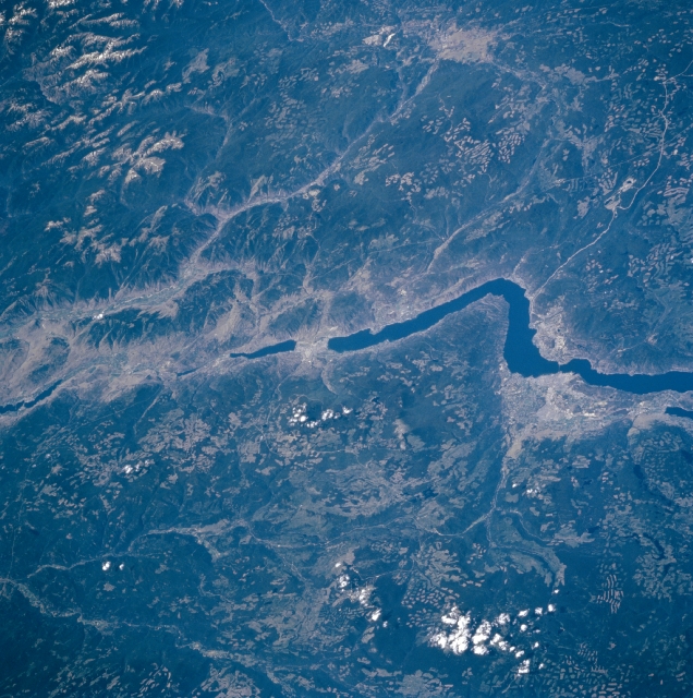 |
| STS085-707-058 Okanagan Lake, British Columbia, Canada August, 1997 The southern portion of Okanagan Lake can be seen in this west-looking view. Located in a prosperous fruit-growing region of Southern British Columbia, Okanagan Lake is 69 miles (111 km) long and from 2 to 4 miles (3 to 6 km) wide. The lake is fed by and its outlet is the Okanagan River, which flows southward and joins the Columbia River in the state of Washington. The lake is a popular all-season resort region for fishing and camping in the summer and skiing and cross-country skiing during the winter. |
| Images: | All Available Images Low-Resolution 389k |
|
| Mission: | STS085 |
|
| Roll - Frame: | 707 - 58 |
|
| Geographical Name: | CANADA-BC |
|
| Features: | OKANAGAN LAKE |
|
| Center Lat x Lon: | 49.5N x 119.5W |
|
| Film Exposure: | N | N=Normal exposure, U=Under exposed, O=Over exposed, F=out of Focus |
| Percentage of Cloud Cover-CLDP: | 5 |
|
| Camera:: | HB |
|
| Camera Tilt: | HO | LO=Low Oblique, HO=High Oblique, NV=Near Vertical |
| Camera Focal Length: | 100 |
|
| Nadir to Photo Center Direction: | SW | The direction from the nadir to the center point, N=North, S=South, E=East, W=West |
| Stereo?: | Y | Y=Yes there is an adjacent picture of the same area, N=No there isn't |
| Orbit Number: | 51 |
|
| Date: | 19970810 | YYYYMMDD |
| Time: | 181330 | GMT HHMMSS |
| Nadir Lat: | 51.6N |
Latitude of suborbital point of spacecraft |
| Nadir Lon: | 116.1W |
Longitude of suborbital point of spacecraft |
| Sun Azimuth: | 143 | Clockwise angle in degrees from north to the sun measured at the nadir point |
| Space Craft Altitude: | 157 | nautical miles |
| Sun Elevation: | 49 | Angle in degrees between the horizon and the sun, measured at the nadir point |
| Land Views: | MOUNTAIN, VALLEY, FOREST, FAULT |
|
| Water Views: | LAKE |
|
| Atmosphere Views: | |
|
| Man Made Views: | |
|
| City Views: | |
|
Photo is not associated with any sequences | ||
| NASA Home Page |
JSC Home Page |
JSC Digital Image Collection |
Earth Science & Remote Sensing |
|
This service is provided by the International Space Station program and the JSC Earth Science & Remote Sensing Unit, ARES Division, Exploration Integration Science Directorate.

|