
Geographic Region: USA-WASHINGTON
Feature: MTS. RAINER & ST. HELENS
|
Geographic Region: USA-WASHINGTON Feature: MTS. RAINER & ST. HELENS |
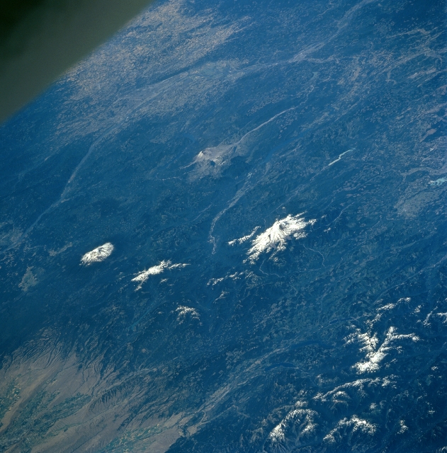 |
| STS085-707-055 Cascade Range, Washington August, 1997 The volcanic peaks of Mount Rainier (just right of the center of the image), Mount St. Helens (just to the top of the center of the image), and Mount Adams (near the left center of the image) in the Cascade Range of central and southern Washington, can be seen in this south-southwest-looking view. The Cascade Range, a part of the Pacific Ring of Fire, extends 700 miles (1125 km) from British Columbia, Canada southward into northern California. The Cascade Range was formed by colliding tectonic plates (North America and Juan de Fuca) and volcanic activity, and these forces continue to make the Cascades rise. Mount Rainier at 14410 feet (4395 meters) is the highest point in the range. Forests cover extensive areas of the Cascade Range. The small city of Hood River, Oregon and the Columbia River Gorge are can be seen at the left center of the image. The city of Portland, Oregon (barely discernible) and the Willamette River Valley are visible near the top left and top center of the image. |
| Images: | All Available Images Low-Resolution 351k |
|
| Mission: | STS085 |
|
| Roll - Frame: | 707 - 55 |
|
| Geographical Name: | USA-WASHINGTON |
|
| Features: | MTS. RAINER & ST. HELENS |
|
| Center Lat x Lon: | 46.5N x 121.5W |
|
| Film Exposure: | N | N=Normal exposure, U=Under exposed, O=Over exposed, F=out of Focus |
| Percentage of Cloud Cover-CLDP: | 0 |
|
| Camera:: | HB |
|
| Camera Tilt: | LO | LO=Low Oblique, HO=High Oblique, NV=Near Vertical |
| Camera Focal Length: | 100 |
|
| Nadir to Photo Center Direction: | SW | The direction from the nadir to the center point, N=North, S=South, E=East, W=West |
| Stereo?: | Y | Y=Yes there is an adjacent picture of the same area, N=No there isn't |
| Orbit Number: | 51 |
|
| Date: | 19970810 | YYYYMMDD |
| Time: | 181306 | GMT HHMMSS |
| Nadir Lat: | 50.8N |
Latitude of suborbital point of spacecraft |
| Nadir Lon: | 118.2W |
Longitude of suborbital point of spacecraft |
| Sun Azimuth: | 140 | Clockwise angle in degrees from north to the sun measured at the nadir point |
| Space Craft Altitude: | 157 | nautical miles |
| Sun Elevation: | 49 | Angle in degrees between the horizon and the sun, measured at the nadir point |
| Land Views: | MOUNTAIN, VOLCANO, FOREST, VALLEY |
|
| Water Views: | |
|
| Atmosphere Views: | |
|
| Man Made Views: | |
|
| City Views: | |
|
Photo is not associated with any sequences | ||
| NASA Home Page |
JSC Home Page |
JSC Digital Image Collection |
Earth Science & Remote Sensing |
|
This service is provided by the International Space Station program and the JSC Earth Science & Remote Sensing Unit, ARES Division, Exploration Integration Science Directorate.

|