
Geographic Region: ROMANIA
Feature: DANUBE RIVER DELTA, LAKE RAZELM
|
Geographic Region: ROMANIA Feature: DANUBE RIVER DELTA, LAKE RAZELM |
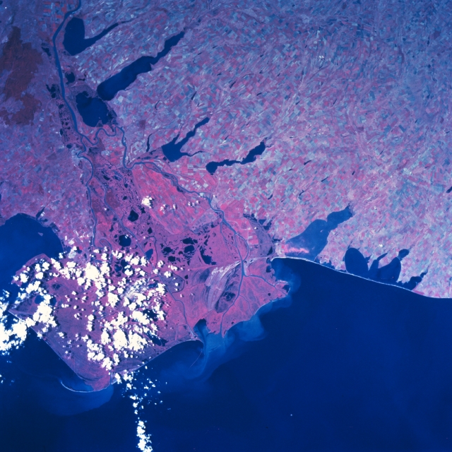 |
| STS085-704-022 Danube River Delta, Romania August 1997 The delta of the great Danube River is a large, low-lying wetland region in northeastern Romania. Designed by the United Nations as a "Reservation of the Biosphere", this unique ecological delta covers approximately 2200 squire miles (5640 square kilometers and borders the northwest corner of the Black Sea. Sediment plumes (light colored water) are visible at various locations at the mouths of the delta. The region has been described by many scientists and environmentalists as a natural paradise and wildlife sanctuary where canals, lakes (many small, dark features within the delta), reed islands, pastures, and sand dunes combine to create this unique environment. The color infrared image helps to discriminate numerous distributary channels and lakes within the deltaic swamp, although cloud cover does obscure the southern half of the delta. The vibrant red-colors indicate healthy green vegetation. The deep reddish feature (upper left corner) appears to be a forested region on the northwest corner of the Dobruja Plateau. All of the large, north-south oriented lakes (elongated, irregular-shaped, dark features) are located in the Ukraine. The main most northerly channel of the Danube River serves as the border between Romania and the Ukraine. The southern coastal plain of the Ukraine shows an extensive agricultural pattern throughout the region. |
| Images: | All Available Images Low-Resolution 346k |
|
| Mission: | STS085 |
|
| Roll - Frame: | 704 - 22 |
|
| Geographical Name: | ROMANIA |
|
| Features: | DANUBE RIVER DELTA, LAKE RAZELM |
|
| Center Lat x Lon: | 45.0N x 29.0E |
|
| Film Exposure: | N | N=Normal exposure, U=Under exposed, O=Over exposed, F=out of Focus |
| Percentage of Cloud Cover-CLDP: | 10 |
|
| Camera:: | HB |
|
| Camera Tilt: | 13 | LO=Low Oblique, HO=High Oblique, NV=Near Vertical |
| Camera Focal Length: | 100 |
|
| Nadir to Photo Center Direction: | N | The direction from the nadir to the center point, N=North, S=South, E=East, W=West |
| Stereo?: | Y | Y=Yes there is an adjacent picture of the same area, N=No there isn't |
| Orbit Number: | 174 |
|
| Date: | 19970818 | YYYYMMDD |
| Time: | 112243 | GMT HHMMSS |
| Nadir Lat: | 44.5N |
Latitude of suborbital point of spacecraft |
| Nadir Lon: | 29.2E |
Longitude of suborbital point of spacecraft |
| Sun Azimuth: | 213 | Clockwise angle in degrees from north to the sun measured at the nadir point |
| Space Craft Altitude: | 138 | nautical miles |
| Sun Elevation: | 55 | Angle in degrees between the horizon and the sun, measured at the nadir point |
| Land Views: | PLAIN |
|
| Water Views: | DELTA, RIVER |
|
| Atmosphere Views: | |
|
| Man Made Views: | |
|
| City Views: | |
|
Photo is not associated with any sequences | ||
| NASA Home Page |
JSC Home Page |
JSC Digital Image Collection |
Earth Science & Remote Sensing |
|
This service is provided by the International Space Station program and the JSC Earth Science & Remote Sensing Unit, ARES Division, Exploration Integration Science Directorate.

|