 Photo #: STS085-508-24 Date: Aug. 1997
Geographic Region: USA-NEW JERSEY
Feature: DELAWARE R.,BARNEGAT BAY

 Photo #: STS085-508-24 Date: Aug. 1997 Photo #: STS085-508-24 Date: Aug. 1997Geographic Region: USA-NEW JERSEY Feature: DELAWARE R.,BARNEGAT BAY |
 |
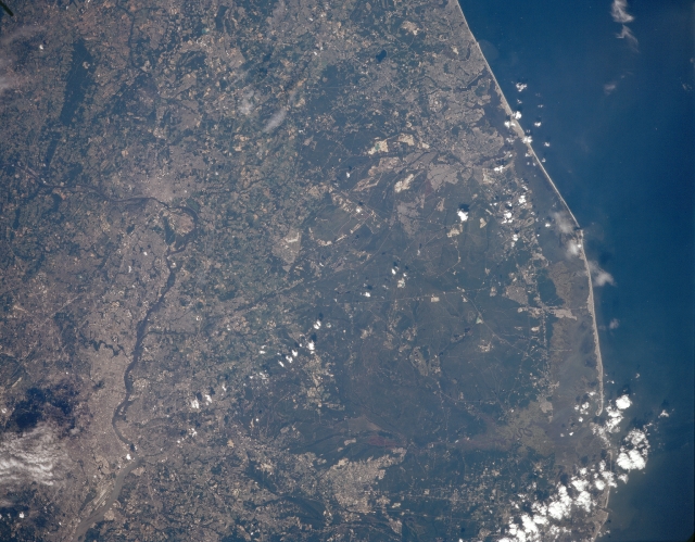
| STS085-508-024 Delaware River, Pine Barrens, New Jersey August 1997 The Delaware River, the central New Jersey Coast, and the Pine Barrens are all visible in this north-northeast-looking low-oblique view. The Delaware River, 280 miles (450 km) long, rises in the Catskill Mountains of New York, enters the scene just above the left center of the image and flows generally southeastward passing Trenton, before turning southwestward. The river is most apparent as it passes Trenton and then exits the scene at the bottom left of the image. The large forested area covering much of the right half of the image is the Pine Barrens area of south-central New Jersey. A vast forest of pine, oak, and cedar on the outer coastal-plain, the Pine Barrens cover an area of 3000 sq. miles (7700 sq. km), and is the largest tract of open space on the mid-Atlantic Coast in what is the most urbanized state in the United States. The area is characterized by gently rolling terrain and sandy soils, swamp-edged streams, and tracts of cranberries and blueberries. Most of the Pine Barrens lies within a national reserve administered by the New Jersey Pinelands Commission. |
| Images: | All Available Images Low-Resolution 289k |
|
| Mission: | STS085 |
|
| Roll - Frame: | 508 - 24 |
|
| Geographical Name: | USA-NEW JERSEY |
|
| Features: | DELAWARE R.,BARNEGAT BAY |
|
| Center Lat x Lon: | 40.0N x 74.5W |
|
| Film Exposure: | N | N=Normal exposure, U=Under exposed, O=Over exposed, F=out of Focus |
| Percentage of Cloud Cover-CLDP: | 5 |
|
| Camera:: | LH |
|
| Camera Tilt: | 14 | LO=Low Oblique, HO=High Oblique, NV=Near Vertical |
| Camera Focal Length: | 250 |
|
| Nadir to Photo Center Direction: | NW | The direction from the nadir to the center point, N=North, S=South, E=East, W=West |
| Stereo?: | Y | Y=Yes there is an adjacent picture of the same area, N=No there isn't |
| Orbit Number: | 163 |
|
| Date: | 19970817 | YYYYMMDD |
| Time: | 185904 | GMT HHMMSS |
| Nadir Lat: | 39.7N |
Latitude of suborbital point of spacecraft |
| Nadir Lon: | 74W |
Longitude of suborbital point of spacecraft |
| Sun Azimuth: | 233 | Clockwise angle in degrees from north to the sun measured at the nadir point |
| Space Craft Altitude: | 138 | nautical miles |
| Sun Elevation: | 53 | Angle in degrees between the horizon and the sun, measured at the nadir point |
| Land Views: | FOREST, COAST |
|
| Water Views: | RIVER, BAY |
|
| Atmosphere Views: | |
|
| Man Made Views: | URBAN AREA |
|
| City Views: | |
|
Photo is not associated with any sequences | ||
| NASA Home Page |
JSC Home Page |
JSC Digital Image Collection |
Earth Science & Remote Sensing |
|
|