
Geographic Region: TURKEY
Feature: KUS LAKE, MARMARA SEA
|
Geographic Region: TURKEY Feature: KUS LAKE, MARMARA SEA |
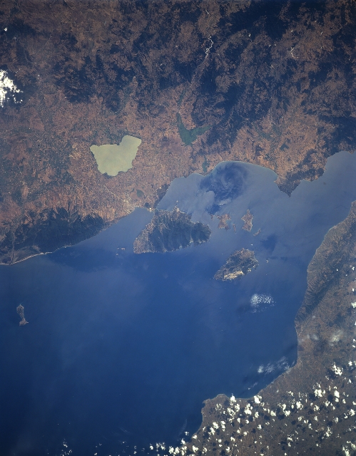 |
| STS085-505-062 Sea of Marmara, Turkey August 1997 The small inland Sea of Marmara (The Sea of Marble), between the European (bottom) Turkey and Asiatic (upper) Turkey, can be seen in this south-southwest-looking view. The sea is 170 miles (275 km) long and 50 miles (80 km) at its maximum width. The Sea of Marmara covers an area of 4,300 square miles (11,800 square km). Its maximum depth is about 4,500 feet (1370 meters) and there are no strong currents. The tidal range is minimum. The Sea of Marmara is a strategically important sea route for the shipping fleets of the world that travel between the Black Sea and the Mediterranean Sea. Numerous islands are situated in the Sea of Marmara, including the island of Marmara (lower right quadrant) where marble and alabaster are quarried. |
| Images: | All Available Images Low-Resolution 267k |
|
| Mission: | STS085 |
|
| Roll - Frame: | 505 - 62 |
|
| Geographical Name: | TURKEY |
|
| Features: | KUS LAKE, MARMARA SEA |
|
| Center Lat x Lon: | 40.5N x 27.5E |
|
| Film Exposure: | N | N=Normal exposure, U=Under exposed, O=Over exposed, F=out of Focus |
| Percentage of Cloud Cover-CLDP: | 5 |
|
| Camera:: | LH |
|
| Camera Tilt: | LO | LO=Low Oblique, HO=High Oblique, NV=Near Vertical |
| Camera Focal Length: | 250 |
|
| Nadir to Photo Center Direction: | The direction from the nadir to the center point, N=North, S=South, E=East, W=West |
|
| Stereo?: | Y | Y=Yes there is an adjacent picture of the same area, N=No there isn't |
| Orbit Number: | |
|
| Date: | 199708__ | YYYYMMDD |
| Time: | GMT HHMMSS |
|
| Nadir Lat: | N |
Latitude of suborbital point of spacecraft |
| Nadir Lon: | E |
Longitude of suborbital point of spacecraft |
| Sun Azimuth: | Clockwise angle in degrees from north to the sun measured at the nadir point |
|
| Space Craft Altitude: | nautical miles |
|
| Sun Elevation: | Angle in degrees between the horizon and the sun, measured at the nadir point |
|
| Land Views: | PLAIN, ISLAND |
|
| Water Views: | SEA |
|
| Atmosphere Views: | |
|
| Man Made Views: | MINING |
|
| City Views: | |
|
Photo is not associated with any sequences | ||
| NASA Home Page |
JSC Home Page |
JSC Digital Image Collection |
Earth Science & Remote Sensing |
|
This service is provided by the International Space Station program and the JSC Earth Science & Remote Sensing Unit, ARES Division, Exploration Integration Science Directorate.

|