
Geographic Region: OMAN
Feature: WAHIBAH SANDS, OMAN MTS.
|
Geographic Region: OMAN Feature: WAHIBAH SANDS, OMAN MTS. |
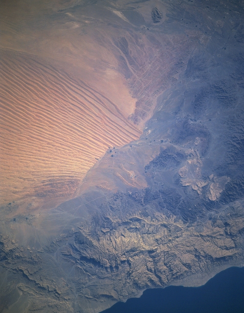 |
| STS085-501-014 Wahiba Sands, Green Mountain Range, Oman August 1997 The eastern extension of the vast Rub-al-Khali Desert or Empty Quarter, the red and golden dunes (650 feet-200 meters) of the Wahiba Sands in southeast Oman (upper left quadrant) is visible in this southwest-looking view. The predominant winds in the area give the longitudinal dunes the north to south alignment. The mountainous terrain that extends diagonally across the bottom of the image is the Al Jabal al Akhdar or Green Mountain Range, which reach altitudes exceeding 5500 feet (1678 meters). Formed nearly 80 million years ago, the range is a large anticline that is flanked by hard limestone and mantle rocks. Monsoon winds bring moisture-laden air in from the Gulf of Oman (bottom right). As the air rises over the Green Mountain Range, the rising air cools, and rainfall occurs at the higher elevations within the range. Several wadis or waterways drain the Green Mountain Range. Forests are scattered throughout the range. |
| Images: | All Available Images Low-Resolution 272k |
|
| Mission: | STS085 |
|
| Roll - Frame: | 501 - 14 |
|
| Geographical Name: | OMAN |
|
| Features: | WAHIBAH SANDS, OMAN MTS. |
|
| Center Lat x Lon: | 22.5N x 55.0E |
|
| Film Exposure: | N | N=Normal exposure, U=Under exposed, O=Over exposed, F=out of Focus |
| Percentage of Cloud Cover-CLDP: | 0 |
|
| Camera:: | LH |
|
| Camera Tilt: | LO | LO=Low Oblique, HO=High Oblique, NV=Near Vertical |
| Camera Focal Length: | 250 |
|
| Nadir to Photo Center Direction: | The direction from the nadir to the center point, N=North, S=South, E=East, W=West |
|
| Stereo?: | Y | Y=Yes there is an adjacent picture of the same area, N=No there isn't |
| Orbit Number: | |
|
| Date: | 199708__ | YYYYMMDD |
| Time: | GMT HHMMSS |
|
| Nadir Lat: | N |
Latitude of suborbital point of spacecraft |
| Nadir Lon: | E |
Longitude of suborbital point of spacecraft |
| Sun Azimuth: | Clockwise angle in degrees from north to the sun measured at the nadir point |
|
| Space Craft Altitude: | nautical miles |
|
| Sun Elevation: | Angle in degrees between the horizon and the sun, measured at the nadir point |
|
| Land Views: | MOUNTAIN, DESERT, DUNE, COAST, ESCARPMENT |
|
| Water Views: | GULF |
|
| Atmosphere Views: | |
|
| Man Made Views: | |
|
| City Views: | |
|
Photo is not associated with any sequences | ||
| NASA Home Page |
JSC Home Page |
JSC Digital Image Collection |
Earth Science & Remote Sensing |
|
This service is provided by the International Space Station program and the JSC Earth Science & Remote Sensing Unit, ARES Division, Exploration Integration Science Directorate.

|