
Geographic Region: CANADA-M
Feature: PELICAN,ROCK & SWAN LAKE
|
Geographic Region: CANADA-M Feature: PELICAN,ROCK & SWAN LAKE |
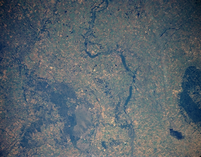 |
| STS085-501-133 Pembina River Basin, Manitoba, Canada August 1997 The Pembina River and at least three elongated, intermittent lakes, including Pelican and Swan Lakes, (dark features) are visible where the river winds its way in an easterly direction across the plains of southwestern Manitoba. Landmarks in the scene include a section of the International Peace Garden (large forested area along the southern edge of the picture), which straddles the Canada-U. S. border; Whitewater Lake (smaller, dark feature immediately north of the International Peace Garden); and the dark forested area north of the Pembina River is Spruce Woods Provincial Park. The lighter colored, uniform-looking terrain south of the forested park is an area of open sand dunes, known as Canada's Living Desert. The wildly meandering course of the eastward flowing Assiniboine River is also visible south of the sand dunes (Baldhills Park) and Spruce Woods Provincial Park. Most of the land that is suitable for agriculture is used for the production of spring wheat. |
| Images: | All Available Images Low-Resolution 320k |
|
| Mission: | STS085 |
|
| Roll - Frame: | 501 - 133 |
|
| Geographical Name: | CANADA-M |
|
| Features: | PELICAN,ROCK & SWAN LAKE |
|
| Center Lat x Lon: | 49.5N x 99W |
|
| Film Exposure: | N | N=Normal exposure, U=Under exposed, O=Over exposed, F=out of Focus |
| Percentage of Cloud Cover-CLDP: | 0 |
|
| Camera:: | LH |
|
| Camera Tilt: | 39 | LO=Low Oblique, HO=High Oblique, NV=Near Vertical |
| Camera Focal Length: | 250 |
|
| Nadir to Photo Center Direction: | W | The direction from the nadir to the center point, N=North, S=South, E=East, W=West |
| Stereo?: | Y | Y=Yes there is an adjacent picture of the same area, N=No there isn't |
| Orbit Number: | 97 |
|
| Date: | 19970813 | YYYYMMDD |
| Time: | 152727 | GMT HHMMSS |
| Nadir Lat: | 49.2N |
Latitude of suborbital point of spacecraft |
| Nadir Lon: | 96.9W |
Longitude of suborbital point of spacecraft |
| Sun Azimuth: | 116 | Clockwise angle in degrees from north to the sun measured at the nadir point |
| Space Craft Altitude: | 155 | nautical miles |
| Sun Elevation: | 39 | Angle in degrees between the horizon and the sun, measured at the nadir point |
| Land Views: | FOREST, DUNE |
|
| Water Views: | RIVER, LAKE |
|
| Atmosphere Views: | |
|
| Man Made Views: | |
|
| City Views: | |
|
Photo is not associated with any sequences | ||
| NASA Home Page |
JSC Home Page |
JSC Digital Image Collection |
Earth Science & Remote Sensing |
|
This service is provided by the International Space Station program and the JSC Earth Science & Remote Sensing Unit, ARES Division, Exploration Integration Science Directorate.

|