
Geographic Region: USA-CALIFORNIA
Feature: EDWARDS AFB, MOUNTAINS
|
Geographic Region: USA-CALIFORNIA Feature: EDWARDS AFB, MOUNTAINS |
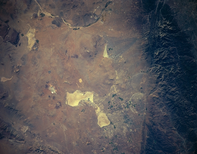 |
| STS085-501-114 Mojave Desert, California, USA August 1997 Rogers Dry Lake and Rosamond Dry Lake (extensive, light colored feature) are located toward the center of the Mojave Desert near the western apex of the desert. Both dry lakes are part of Edwards Air Force Base that includes an alternate landing site for NASA's Space Shuttle. The Mojave River is the dark and light, gently curving linear feature at the top of the image. The dark-looking feature along the southwest side of the picture is part of the northeast flank of the San Gabriel Mountains. A section of the San Andreas fault (linear structure) can also be detected. A very small section of the Garlock fault (not as obvious as the San Andreas fault) can be traced across the landscape along the northwest side of the valley. This frame of photography overlaps with STS085-501-116. |
| Images: | All Available Images Low-Resolution 274k |
|
| Mission: | STS085 |
|
| Roll - Frame: | 501 - 114 |
|
| Geographical Name: | USA-CALIFORNIA |
|
| Features: | EDWARDS AFB, MOUNTAINS |
|
| Center Lat x Lon: | 34.5N x 117.5W |
|
| Film Exposure: | N | N=Normal exposure, U=Under exposed, O=Over exposed, F=out of Focus |
| Percentage of Cloud Cover-CLDP: | 0 |
|
| Camera:: | LH |
|
| Camera Tilt: | LO | LO=Low Oblique, HO=High Oblique, NV=Near Vertical |
| Camera Focal Length: | 250 |
|
| Nadir to Photo Center Direction: | The direction from the nadir to the center point, N=North, S=South, E=East, W=West |
|
| Stereo?: | Y | Y=Yes there is an adjacent picture of the same area, N=No there isn't |
| Orbit Number: | |
|
| Date: | 199708__ | YYYYMMDD |
| Time: | GMT HHMMSS |
|
| Nadir Lat: | N |
Latitude of suborbital point of spacecraft |
| Nadir Lon: | E |
Longitude of suborbital point of spacecraft |
| Sun Azimuth: | Clockwise angle in degrees from north to the sun measured at the nadir point |
|
| Space Craft Altitude: | nautical miles |
|
| Sun Elevation: | Angle in degrees between the horizon and the sun, measured at the nadir point |
|
| Land Views: | DESERT, FAULT |
|
| Water Views: | RIVER, PLAYA |
|
| Atmosphere Views: | |
|
| Man Made Views: | AIRPORT, AGRICULTURE |
|
| City Views: | |
|
Photo is not associated with any sequences | ||
| NASA Home Page |
JSC Home Page |
JSC Digital Image Collection |
Earth Science & Remote Sensing |
|
This service is provided by the International Space Station program and the JSC Earth Science & Remote Sensing Unit, ARES Division, Exploration Integration Science Directorate.

|