
Geographic Region: ISRAEL
Feature: GAZA STRIP
|
Geographic Region: ISRAEL Feature: GAZA STRIP |
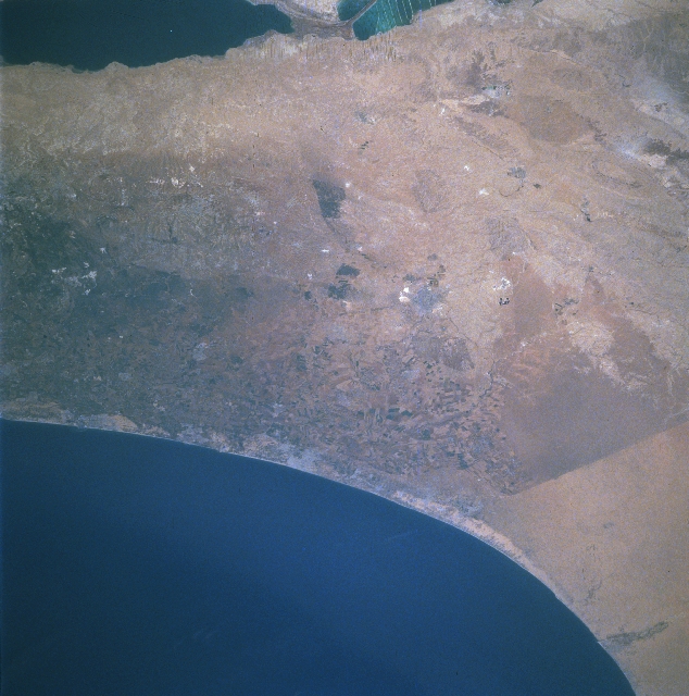 |
| STS084-728-099 The Negev Desert, Gaza Strip, Israel May 1997 The region of south and southwest Israel can be seen in this mostly east-looking view. The southern Central Hills, an area of low hills and many small valleys, is visible at the left center of the image. A portion of the Dead Sea, the lowest point on earth, is visible at the upper left of the image. In the upper right and right center of the image, the Negev Desert, an area of low hills, is discernible. Parts of the Negev Desert are under irrigation as can be seen on the border between Israel and the Sinai Peninsula of Egypt just below the right center of the image. Minerals such as copper, phosphates, and natural gas are also commercially extracted from the Negev Desert. Just below the center of the image and along the Mediterranean Sea coast is the Gaza Strip. The Gaza Strip is a narrow area of desert land that is 26 miles (42 km) long and from 4 to 5 miles (6 to 8 km) wide. The strip is densely populated and impoverished with more than 99 percent of the population being Arab refugees from Israel. The modest economy of the Gaza Strip is based on agriculture, livestock, fishing, and some small industry. |
| Images: | All Available Images Low-Resolution 334k |
|
| Mission: | STS084 |
|
| Roll - Frame: | 728 - 99 |
|
| Geographical Name: | ISRAEL |
|
| Features: | GAZA STRIP |
|
| Center Lat x Lon: | 31.5N x 35.0E |
|
| Film Exposure: | N | N=Normal exposure, U=Under exposed, O=Over exposed, F=out of Focus |
| Percentage of Cloud Cover-CLDP: | 0 |
|
| Camera:: | HB |
|
| Camera Tilt: | LO | LO=Low Oblique, HO=High Oblique, NV=Near Vertical |
| Camera Focal Length: | 250 |
|
| Nadir to Photo Center Direction: | The direction from the nadir to the center point, N=North, S=South, E=East, W=West |
|
| Stereo?: | N | Y=Yes there is an adjacent picture of the same area, N=No there isn't |
| Orbit Number: | |
|
| Date: | 19970519 | YYYYMMDD |
| Time: | GMT HHMMSS |
|
| Nadir Lat: | N |
Latitude of suborbital point of spacecraft |
| Nadir Lon: | E |
Longitude of suborbital point of spacecraft |
| Sun Azimuth: | Clockwise angle in degrees from north to the sun measured at the nadir point |
|
| Space Craft Altitude: | nautical miles |
|
| Sun Elevation: | Angle in degrees between the horizon and the sun, measured at the nadir point |
|
| Land Views: | DESERT, COAST, HILL |
|
| Water Views: | SEA |
|
| Atmosphere Views: | |
|
| Man Made Views: | AGRICULTURE, MINING |
|
| City Views: | |
|
Photo is not associated with any sequences | ||
| NASA Home Page |
JSC Home Page |
JSC Digital Image Collection |
Earth Science & Remote Sensing |
|
This service is provided by the International Space Station program and the JSC Earth Science & Remote Sensing Unit, ARES Division, Exploration Integration Science Directorate.

|