
Geographic Region: PERU
Feature: COAST, LIMA/CALLAO
|
Geographic Region: PERU Feature: COAST, LIMA/CALLAO |
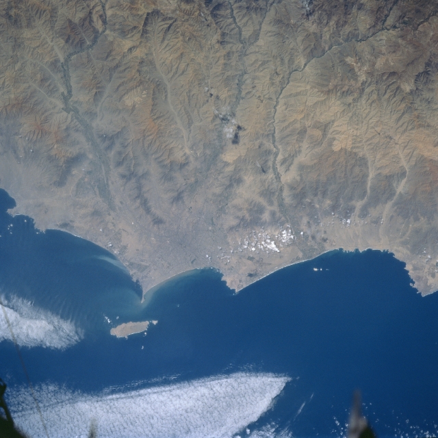 |
| STS084-727-053 Lima/Callo Area, Peru May 1997 The coastal area of Peru is a desolate, rocky or sandy desert that extends from Ecuador to Chile. As seen on this image, the arid environment is broken only by short-flowing rivers that rapidly descend through the western flank of the Andes Mountains as deeply eroded and incised river valleys. Over fifty percent of Peru's population lives in the coastal valleys where irrigated agriculture is possible. The capitol, Lima, and its port city of Callao (barely visible in this small scale picture), are located along the coast near the center of the image. The island of San Lorenzo is located immediately offshore of the Callao-Lima urban area. The human settlements in the coastal valleys are totally dependent on water that flows from the Andes Mountains along canals and aqueducts that were built thousands of years ago. |
| Images: | All Available Images Low-Resolution 301k |
|
| Mission: | STS084 |
|
| Roll - Frame: | 727 - 53 |
|
| Geographical Name: | PERU |
|
| Features: | COAST, LIMA/CALLAO |
|
| Center Lat x Lon: | 12S x 77W |
|
| Film Exposure: | N | N=Normal exposure, U=Under exposed, O=Over exposed, F=out of Focus |
| Percentage of Cloud Cover-CLDP: | 5 |
|
| Camera:: | HB |
|
| Camera Tilt: | 15 | LO=Low Oblique, HO=High Oblique, NV=Near Vertical |
| Camera Focal Length: | 250 |
|
| Nadir to Photo Center Direction: | SE | The direction from the nadir to the center point, N=North, S=South, E=East, W=West |
| Stereo?: | N | Y=Yes there is an adjacent picture of the same area, N=No there isn't |
| Orbit Number: | 54 |
|
| Date: | 19970518 | YYYYMMDD |
| Time: | 173514 | GMT HHMMSS |
| Nadir Lat: | 11.2S |
Latitude of suborbital point of spacecraft |
| Nadir Lon: | 77.5W |
Longitude of suborbital point of spacecraft |
| Sun Azimuth: | 347 | Clockwise angle in degrees from north to the sun measured at the nadir point |
| Space Craft Altitude: | 214 | nautical miles |
| Sun Elevation: | 58 | Angle in degrees between the horizon and the sun, measured at the nadir point |
| Land Views: | DESERT, COAST, MOUNTAIN |
|
| Water Views: | RIVER |
|
| Atmosphere Views: | |
|
| Man Made Views: | |
|
| City Views: | |
|
Photo is not associated with any sequences | ||
| NASA Home Page |
JSC Home Page |
JSC Digital Image Collection |
Earth Science & Remote Sensing |
|
This service is provided by the International Space Station program and the JSC Earth Science & Remote Sensing Unit, ARES Division, Exploration Integration Science Directorate.

|