
Geographic Region: PERU
Feature: COAST, HUACHO
|
Geographic Region: PERU Feature: COAST, HUACHO |
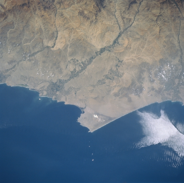 |
| STS084-727-049 Huacho Area, Peru May 1997 This particular section of the Peruvian coast northwest of Lima is located in a desert climate. Here it is so arid that only the intermittently flowing rivers provide adequate moisture to support irrigated agriculture in the river valleys and floodplains (note the darker linear features aligned east-west in the image). Many of the deeply incised, short flowing rivers drop dramatically in elevation from 15000 feet (4572 meters) elevation in the Andes Mountains to sea level in less than 50 miles (80 kilometers). The small, brighter features that are visible on the peninsula that juts westward into the Pacific Ocean are the salt pans of mining operations. The tiny town of Huacho is located at the coast near the Rio de Huaura, just north of the large peninsula where the agricultural field pattern is most extensive. |
| Images: | All Available Images Low-Resolution 286k |
|
| Mission: | STS084 |
|
| Roll - Frame: | 727 - 49 |
|
| Geographical Name: | PERU |
|
| Features: | COAST, HUACHO |
|
| Center Lat x Lon: | 11S x 77.5W |
|
| Film Exposure: | N | N=Normal exposure, U=Under exposed, O=Over exposed, F=out of Focus |
| Percentage of Cloud Cover-CLDP: | 5 |
|
| Camera:: | HB |
|
| Camera Tilt: | 15 | LO=Low Oblique, HO=High Oblique, NV=Near Vertical |
| Camera Focal Length: | 250 |
|
| Nadir to Photo Center Direction: | SE | The direction from the nadir to the center point, N=North, S=South, E=East, W=West |
| Stereo?: | N | Y=Yes there is an adjacent picture of the same area, N=No there isn't |
| Orbit Number: | 54 |
|
| Date: | 19970518 | YYYYMMDD |
| Time: | 173456 | GMT HHMMSS |
| Nadir Lat: | 10.3S |
Latitude of suborbital point of spacecraft |
| Nadir Lon: | 78.2W |
Longitude of suborbital point of spacecraft |
| Sun Azimuth: | 348 | Clockwise angle in degrees from north to the sun measured at the nadir point |
| Space Craft Altitude: | 214 | nautical miles |
| Sun Elevation: | 59 | Angle in degrees between the horizon and the sun, measured at the nadir point |
| Land Views: | DESERT, COAST, FLOOD PLAIN |
|
| Water Views: | RIVER |
|
| Atmosphere Views: | |
|
| Man Made Views: | AGRICULTURE |
|
| City Views: | |
|
Photo is not associated with any sequences | ||
| NASA Home Page |
JSC Home Page |
JSC Digital Image Collection |
Earth Science & Remote Sensing |
|
This service is provided by the International Space Station program and the JSC Earth Science & Remote Sensing Unit, ARES Division, Exploration Integration Science Directorate.

|