Geographic Region: PERU
Feature: COAST, CHIMBOTE
|
Geographic Region: PERU Feature: COAST, CHIMBOTE |
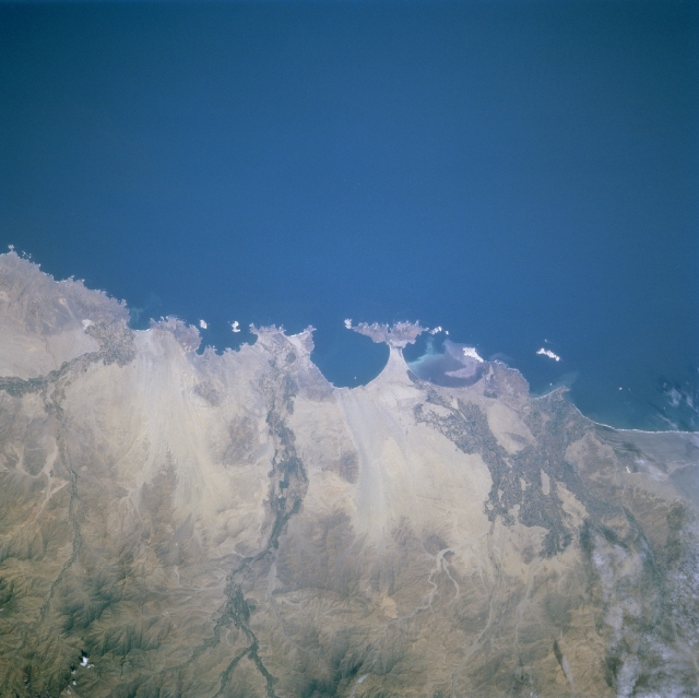 |
| STS084-727-046 Chimbote Area, Peru May 1997 The west central coast of Peru north of Lima offers of a variety of peninsulas and small bays. The narrow coastal plains are covered with light-colored, sandy soils that strongly contrast with the Pacific Ocean. The only breaks in this desert landscape are where the river valleys or channels provide sufficient water for irrigated agriculture. Three distinct (darker textured) agricultural areas are observed here. The largest is located inland from the urban area of the seaport city of Chimbote (located along the northern shore of the second largest bay). Two extensive areas of cultivated field patterns are also observed along the floodplains of the Rio Nepena and Rio Casma, respectively, reaching the coast further south. The western slopes of the Andes Mountains are visible along the bottom of the image. |
| Images: | All Available Images Low-Resolution 269k |
|
| Mission: | STS084 |
|
| Roll - Frame: | 727 - 46 |
|
| Geographical Name: | PERU |
|
| Features: | COAST, CHIMBOTE |
|
| Center Lat x Lon: | 9S x 78.5W |
|
| Film Exposure: | N | N=Normal exposure, U=Under exposed, O=Over exposed, F=out of Focus |
| Percentage of Cloud Cover-CLDP: | 0 |
|
| Camera:: | HB |
|
| Camera Tilt: | 15 | LO=Low Oblique, HO=High Oblique, NV=Near Vertical |
| Camera Focal Length: | 250 |
|
| Nadir to Photo Center Direction: | E | The direction from the nadir to the center point, N=North, S=South, E=East, W=West |
| Stereo?: | N | Y=Yes there is an adjacent picture of the same area, N=No there isn't |
| Orbit Number: | 54 |
|
| Date: | 19970518 | YYYYMMDD |
| Time: | 173423 | GMT HHMMSS |
| Nadir Lat: | 8.6S |
Latitude of suborbital point of spacecraft |
| Nadir Lon: | 79.4W |
Longitude of suborbital point of spacecraft |
| Sun Azimuth: | 350 | Clockwise angle in degrees from north to the sun measured at the nadir point |
| Space Craft Altitude: | 214 | nautical miles |
| Sun Elevation: | 61 | Angle in degrees between the horizon and the sun, measured at the nadir point |
| Land Views: | DESERT, COAST, FLOOD PLAIN |
|
| Water Views: | RIVER |
|
| Atmosphere Views: | |
|
| Man Made Views: | AGRICULTURE |
|
| City Views: | |
|
Photo is not associated with any sequences | ||
| NASA Home Page |
JSC Home Page |
JSC Digital Image Collection |
Earth Science & Remote Sensing |
|
This service is provided by the International Space Station program and the JSC Earth Science & Remote Sensing Unit, ARES Division, Exploration Integration Science Directorate.

|