Geographic Region: RUSSIAN FEDERATION
Feature: L. BAIKAL, SELENGA R. D.
|
Geographic Region: RUSSIAN FEDERATION Feature: L. BAIKAL, SELENGA R. D. |
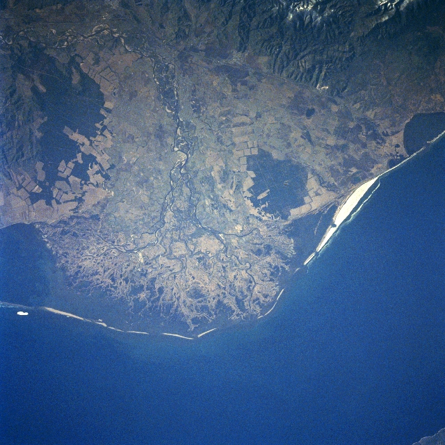 |
| STS084-721-29 Selenga River Delta, Lake Baykal, Russia May 1997 The delta of the Selenga River, emptying into one of the oldest and deepest fresh water lakes in the world, Baykal, can be seen in this east-looking view. The Selenga River rises in the Khangai Mountains of northwest Mongolia and flows 616 miles (991 km) to its mouth at Lake Baykal. The delta is made-up of a swampy-grassy area that is the summer home to numerous birds and other species of wildlife. Industries, especially paper and pulp factories in the Selenga River Valley and in the industrial city of Ulan-Ude, were polluting the Selenga River and Lake Baykal. Since the 1980's, restrictions on the industrial waste dumping have gone in effect, and the flow of the polluted river water into the lake has been reduced significantly, and in some cases, completely stopped. The future of Lake Baykal and its unique environmental habitat looks brighter than it did just a few decades ago. Agricultural fields (angular patterns) can be seen scattered throughout the scene, but are especially noticeable on the lower slopes of hills near the right center of the image. |
| Images: | All Available Images Low-Resolution 382k |
|
| Mission: | STS084 |
|
| Roll - Frame: | 721 - 29 |
|
| Geographical Name: | RUSSIAN FEDERATION |
|
| Features: | L. BAIKAL, SELENGA R. D. |
|
| Center Lat x Lon: | 52.5N x 106.5E |
|
| Film Exposure: | N | N=Normal exposure, U=Under exposed, O=Over exposed, F=out of Focus |
| Percentage of Cloud Cover-CLDP: | 0 |
|
| Camera:: | HB |
|
| Camera Tilt: | LO | LO=Low Oblique, HO=High Oblique, NV=Near Vertical |
| Camera Focal Length: | 250 |
|
| Nadir to Photo Center Direction: | E | The direction from the nadir to the center point, N=North, S=South, E=East, W=West |
| Stereo?: | N | Y=Yes there is an adjacent picture of the same area, N=No there isn't |
| Orbit Number: | |
|
| Date: | 199705__ | YYYYMMDD |
| Time: | GMT HHMMSS |
|
| Nadir Lat: | N |
Latitude of suborbital point of spacecraft |
| Nadir Lon: | E |
Longitude of suborbital point of spacecraft |
| Sun Azimuth: | Clockwise angle in degrees from north to the sun measured at the nadir point |
|
| Space Craft Altitude: | nautical miles |
|
| Sun Elevation: | Angle in degrees between the horizon and the sun, measured at the nadir point |
|
| Land Views: | MOUNTAIN |
|
| Water Views: | RIVER, DELTA, LAKE |
|
| Atmosphere Views: | |
|
| Man Made Views: | AGRICULTURE |
|
| City Views: | |
|
Photo is not associated with any sequences | ||
| NASA Home Page |
JSC Home Page |
JSC Digital Image Collection |
Earth Science & Remote Sensing |
|
This service is provided by the International Space Station program and the JSC Earth Science & Remote Sensing Unit, ARES Division, Exploration Integration Science Directorate.

|