
Geographic Region: ROMANIA
Feature: CONSTANTA, DANUBE RIVER
|
Geographic Region: ROMANIA Feature: CONSTANTA, DANUBE RIVER |
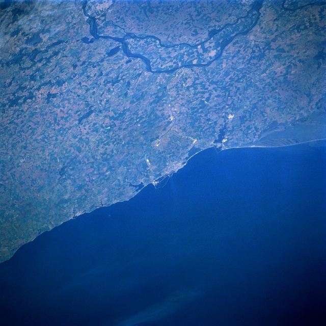 |
| STS084-712-099 Constana Area, Romania May 1997 The southeast region of Romania, the Dobruja Plateau, is highlighted in this oblique, northwest-looking view that includes the western margin of the Black Sea. This upland area of eastern Romania detours the course of the Danube River to the north. The general landscape of the Dobruja region is one of low mountains in the northern section (upper right) and flat to rolling plains with steppe vegetation in the south (near middle of image). Farther inland the Danube River splits into two waterways, thereby creating an extensive floodplain and an island. The angular-looking, patchwork field pattern on the large island indicates that most of the fertile alluvial soil is being used for agriculture. Along the coast the historic, industrial seaport city of Constanta is barely discernible (light color area near center of the image). This tourist city, coupled with a string of beach resorts and health spas along the coast north and south of Constanta, is known as the Romanian Riviera. Many small bays (dark inlets) can be identified along the coastline and the southern end of a large lagoon is visible along the northern edge of the image. |
| Images: | All Available Images Low-Resolution 354k |
|
| Mission: | STS084 |
|
| Roll - Frame: | 712 - 99 |
|
| Geographical Name: | ROMANIA |
|
| Features: | CONSTANTA, DANUBE RIVER |
|
| Center Lat x Lon: | 44.0N x 28.5E |
|
| Film Exposure: | N | N=Normal exposure, U=Under exposed, O=Over exposed, F=out of Focus |
| Percentage of Cloud Cover-CLDP: | 0 |
|
| Camera:: | HB |
|
| Camera Tilt: | LO | LO=Low Oblique, HO=High Oblique, NV=Near Vertical |
| Camera Focal Length: | 250 |
|
| Nadir to Photo Center Direction: | W | The direction from the nadir to the center point, N=North, S=South, E=East, W=West |
| Stereo?: | N | Y=Yes there is an adjacent picture of the same area, N=No there isn't |
| Orbit Number: | 93 |
|
| Date: | 19970521 | YYYYMMDD |
| Time: | 051429 | GMT HHMMSS |
| Nadir Lat: | 44.4N |
Latitude of suborbital point of spacecraft |
| Nadir Lon: | 33.4E |
Longitude of suborbital point of spacecraft |
| Sun Azimuth: | 90 | Clockwise angle in degrees from north to the sun measured at the nadir point |
| Space Craft Altitude: | 205 | nautical miles |
| Sun Elevation: | 30 | Angle in degrees between the horizon and the sun, measured at the nadir point |
| Land Views: | FLOOD PLAIN, COAST |
|
| Water Views: | RIVER, SEA |
|
| Atmosphere Views: | |
|
| Man Made Views: | |
|
| City Views: | |
|
Photo is not associated with any sequences | ||
| NASA Home Page |
JSC Home Page |
JSC Digital Image Collection |
Earth Science & Remote Sensing |
|
This service is provided by the International Space Station program and the JSC Earth Science & Remote Sensing Unit, ARES Division, Exploration Integration Science Directorate.

|