
Geographic Region: AUSTRALIA-NT
Feature: SIR EDWARD PELLEW GROUP
|
Geographic Region: AUSTRALIA-NT Feature: SIR EDWARD PELLEW GROUP |
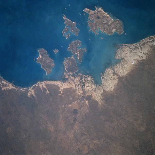 |
| STS084-712-036 Sir Edward Pellew Group, Northern Territory, Australia May 1997 Named for the distinguished British Naval Officer, Sir Edward Pellew, these islands are located just off of the northeast coast of the Northern Territory along the southwest edge of the Gulf of Carpentaria. Although sparsely populated, culturally, this landscape of climatic extremes has been home to an aboriginal people called the Yanyuwa. Intense seasonal variations are the norm. For example the region usually experiences 6 to 8 rainless months per year. The low-lying coastal area (lighter-color) is made up of a mixture of tidal flats, rocky shoreline, and sandy beaches. Vanderlin Island is the largest, most easterly island in the Sir Edward Pellew Group. The waters around these islands are known for excellent sports fishing locations. The coastal areas around the islands also provide suitable feeding habitats for Green Turtles. |
| Images: | All Available Images Low-Resolution 356k |
|
| Mission: | STS084 |
|
| Roll - Frame: | 712 - 36 |
|
| Geographical Name: | AUSTRALIA-NT |
|
| Features: | SIR EDWARD PELLEW GROUP |
|
| Center Lat x Lon: | 16S x 137.0E |
|
| Film Exposure: | N | N=Normal exposure, U=Under exposed, O=Over exposed, F=out of Focus |
| Percentage of Cloud Cover-CLDP: | 0 |
|
| Camera:: | HB |
|
| Camera Tilt: | 26 | LO=Low Oblique, HO=High Oblique, NV=Near Vertical |
| Camera Focal Length: | 250 |
|
| Nadir to Photo Center Direction: | W | The direction from the nadir to the center point, N=North, S=South, E=East, W=West |
| Stereo?: | N | Y=Yes there is an adjacent picture of the same area, N=No there isn't |
| Orbit Number: | 91 |
|
| Date: | 19970521 | YYYYMMDD |
| Time: | 023125 | GMT HHMMSS |
| Nadir Lat: | 16.4S |
Latitude of suborbital point of spacecraft |
| Nadir Lon: | 138.7E |
Longitude of suborbital point of spacecraft |
| Sun Azimuth: | 4 | Clockwise angle in degrees from north to the sun measured at the nadir point |
| Space Craft Altitude: | 214 | nautical miles |
| Sun Elevation: | 53 | Angle in degrees between the horizon and the sun, measured at the nadir point |
| Land Views: | ISLAND |
|
| Water Views: | GULF |
|
| Atmosphere Views: | |
|
| Man Made Views: | |
|
| City Views: | |
|
Photo is not associated with any sequences | ||
| NASA Home Page |
JSC Home Page |
JSC Digital Image Collection |
Earth Science & Remote Sensing |
|
This service is provided by the International Space Station program and the JSC Earth Science & Remote Sensing Unit, ARES Division, Exploration Integration Science Directorate.

|