
Geographic Region: USA-UTAH
Feature: SOUTHERN GREAT SALT LAKE
|
Geographic Region: USA-UTAH Feature: SOUTHERN GREAT SALT LAKE |
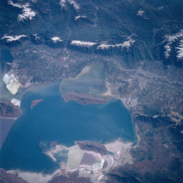 |
| STS084-706-014 Great Salt Lake, Salt Lake City May 1997 The southern half of Great Salt Lake and the cities of Salt Lake and Ogden are visible in this east-looking low-oblique view. Great Salt Lake is the largest natural lake west of the Mississippi River and the largest salt lake in North America with an area of 1000 sq. miles (2590 sq. km). The southern half of the lake is deeper and less salty than the northern half. Near the center of the image is Antelope Island, the largest island within Great Salt Lake. Over 15 miles (24 km) long, the island is a state park, and is home to many forms of wildlife, including a large Buffalo (Bison) herd. The snow-covered peaks of the Wasatch Range, a part of the Rocky Mountains, cover the upper quarter of the image. Salt Lake City, the largest city in Utah, is near the right center of the image. To its north, left center lies the city of Ogden at the base of the Wasatch Mountains. Ogden has many aerospace industries, and is the home of Hill Air Force Base and the Ogden Defense Depot. |
| Images: | All Available Images Low-Resolution 136k |
|
| Mission: | STS084 |
|
| Roll - Frame: | 706 - 14 |
|
| Geographical Name: | USA-UTAH |
|
| Features: | SOUTHERN GREAT SALT LAKE |
|
| Center Lat x Lon: | 41.0N x 112W |
|
| Film Exposure: | N | N=Normal exposure, U=Under exposed, O=Over exposed, F=out of Focus |
| Percentage of Cloud Cover-CLDP: | 0 |
|
| Camera:: | HB |
|
| Camera Tilt: | 38 | LO=Low Oblique, HO=High Oblique, NV=Near Vertical |
| Camera Focal Length: | 250 |
|
| Nadir to Photo Center Direction: | E | The direction from the nadir to the center point, N=North, S=South, E=East, W=West |
| Stereo?: | Y | Y=Yes there is an adjacent picture of the same area, N=No there isn't |
| Orbit Number: | 115 |
|
| Date: | 19970522 | YYYYMMDD |
| Time: | 150534 | GMT HHMMSS |
| Nadir Lat: | 40.5N |
Latitude of suborbital point of spacecraft |
| Nadir Lon: | 114.6W |
Longitude of suborbital point of spacecraft |
| Sun Azimuth: | 88 | Clockwise angle in degrees from north to the sun measured at the nadir point |
| Space Craft Altitude: | 202 | nautical miles |
| Sun Elevation: | 30 | Angle in degrees between the horizon and the sun, measured at the nadir point |
| Land Views: | MOUNTAIN, VALLEY, FOREST, ISLAND |
|
| Water Views: | LAKE, SEDIMENT |
|
| Atmosphere Views: | |
|
| Man Made Views: | URBAN AREA |
|
| City Views: | SALT LAKE CITY |
|
Photo is not associated with any sequences | ||
| NASA Home Page |
JSC Home Page |
JSC Digital Image Collection |
Earth Science & Remote Sensing |
|
This service is provided by the International Space Station program and the JSC Earth Science & Remote Sensing Unit, ARES Division, Exploration Integration Science Directorate.

|