
Geographic Region: USA-FLORIDA
Feature: ST. JOSEPH BAY, CANALS
|
Geographic Region: USA-FLORIDA Feature: ST. JOSEPH BAY, CANALS |
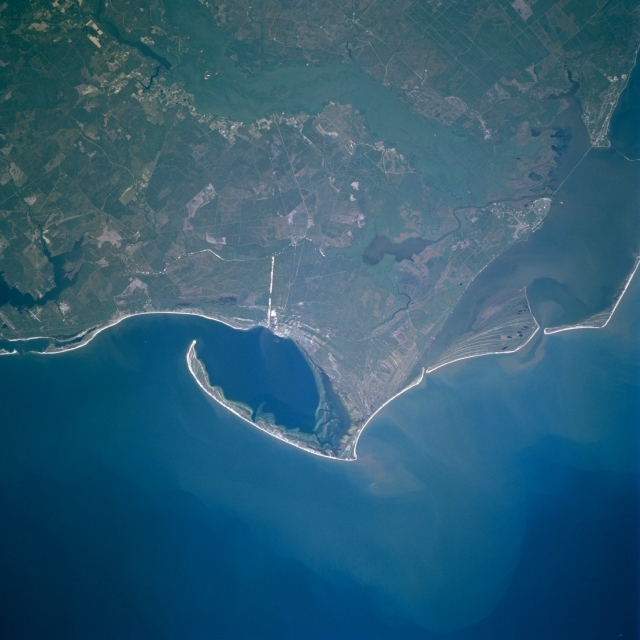 |
| STS083-749-028 Cape San Blas, Florida April, 1997 The Apalachicola Estuary complex and Cape San Blas can be seen in this east-northeast-looking low oblique view. The Apalachicola Estuary is a shallow coastal plain estuary or coastal lagoon that was formed nearly 10000 years ago. The present barrier island system has been in place for the last 5000 years. Just to the right of the center of the image is Saint Vincent Island, a national Wildlife Refuge that covers an area of 19 sq. miles (49 sq. km). Immediately to the right (east) of Saint Vincent is Saint George Island, a narrow barrier island consisting of numerous beaches, sandy coves, salt marshes, and pine and oak forests. To the left (west) of Saint Vincent Island are Cape San Blas and the Saint Joseph Peninsula. The Saint Joseph Peninsula has numerous white sand beaches, dune formations, and a forested interior. The Gulf of Mexico covers the bottom one-third of the image. |
| Images: | All Available Images Low-Resolution 269k |
|
| Mission: | STS083 |
|
| Roll - Frame: | 749 - 28 |
|
| Geographical Name: | USA-FLORIDA |
|
| Features: | ST. JOSEPH BAY, CANALS |
|
| Center Lat x Lon: | 30.0N x 85.5W |
|
| Film Exposure: | N | N=Normal exposure, U=Under exposed, O=Over exposed, F=out of Focus |
| Percentage of Cloud Cover-CLDP: | 0 |
|
| Camera:: | HB |
|
| Camera Tilt: | 28 | LO=Low Oblique, HO=High Oblique, NV=Near Vertical |
| Camera Focal Length: | 250 |
|
| Nadir to Photo Center Direction: | N | The direction from the nadir to the center point, N=North, S=South, E=East, W=West |
| Stereo?: | Y | Y=Yes there is an adjacent picture of the same area, N=No there isn't |
| Orbit Number: | 48 |
|
| Date: | 19970407 | YYYYMMDD |
| Time: | 181209 | GMT HHMMSS |
| Nadir Lat: | 28.6N |
Latitude of suborbital point of spacecraft |
| Nadir Lon: | 85.7W |
Longitude of suborbital point of spacecraft |
| Sun Azimuth: | 198 | Clockwise angle in degrees from north to the sun measured at the nadir point |
| Space Craft Altitude: | 159 | nautical miles |
| Sun Elevation: | 68 | Angle in degrees between the horizon and the sun, measured at the nadir point |
| Land Views: | COAST, DUNE, FOREST |
|
| Water Views: | GULF, SWAMP, RIVER, SEDIMENT, BAY |
|
| Atmosphere Views: | |
|
| Man Made Views: | |
|
| City Views: | |
|
Photo is not associated with any sequences | ||
| NASA Home Page |
JSC Home Page |
JSC Digital Image Collection |
Earth Science & Remote Sensing |
|
This service is provided by the International Space Station program and the JSC Earth Science & Remote Sensing Unit, ARES Division, Exploration Integration Science Directorate.

|