Geographic Region: PHILIPPINES
Feature: MAYON VOLCANO, PLUME
|
Geographic Region: PHILIPPINES Feature: MAYON VOLCANO, PLUME |
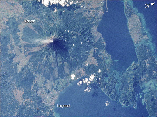 |
| STS083-747-88 Mayon Volcano, Philippines Mayon volcano is the most active volcano in the Philippines, located just north of the coastal town of Legaspi in southern Luzon about 325 km southeast of Manila. Mayon is a near-perfect cone; its steep, forested slopes look rather like a bull's eye when viewed from above. For scale, Mayon's circular footprint is about 16 km in diameter. This photograph was taken from the Space Shuttle on April 8, 1997. At the time the photo was taken, Mayon sported a steam plume from the summit. The lighter (non-forested) regions that radiate from the summit to the southern slopes are flows from eruptions that have occurred over the past twenty-five years. The current eruption, which started June 24, 2001, is sending flows down the southeast slope in the general direction of Legaspi. |
| Images: | All Available Images Low-Resolution 65k |
|
| Mission: | STS083 |
|
| Roll - Frame: | 747 - 88 |
|
| Geographical Name: | PHILIPPINES |
|
| Features: | MAYON VOLCANO, PLUME |
|
| Center Lat x Lon: | 13.5N x 124.0E |
|
| Film Exposure: | N | N=Normal exposure, U=Under exposed, O=Over exposed, F=out of Focus |
| Percentage of Cloud Cover-CLDP: | 10 |
|
| Camera:: | HB |
|
| Camera Tilt: | 13 | LO=Low Oblique, HO=High Oblique, NV=Near Vertical |
| Camera Focal Length: | 250 |
|
| Nadir to Photo Center Direction: | W | The direction from the nadir to the center point, N=North, S=South, E=East, W=West |
| Stereo?: | N | Y=Yes there is an adjacent picture of the same area, N=No there isn't |
| Orbit Number: | 57 |
|
| Date: | 19970408 | YYYYMMDD |
| Time: | 080000 | GMT HHMMSS |
| Nadir Lat: | 13.5N |
Latitude of suborbital point of spacecraft |
| Nadir Lon: | 124.6E |
Longitude of suborbital point of spacecraft |
| Sun Azimuth: | 271 | Clockwise angle in degrees from north to the sun measured at the nadir point |
| Space Craft Altitude: | 161 | nautical miles |
| Sun Elevation: | 27 | Angle in degrees between the horizon and the sun, measured at the nadir point |
| Land Views: | VOLCANO |
|
| Water Views: | |
|
| Atmosphere Views: | PLUME |
|
| Man Made Views: | |
|
| City Views: | |
|
Photo is not associated with any sequences | ||
| NASA Home Page |
JSC Home Page |
JSC Digital Image Collection |
Earth Science & Remote Sensing |
|
This service is provided by the International Space Station program and the JSC Earth Science & Remote Sensing Unit, ARES Division, Exploration Integration Science Directorate.

|