
Geographic Region: AUSTRALIA-T
Feature: FLINDERS ISLAND
|
Geographic Region: AUSTRALIA-T Feature: FLINDERS ISLAND |
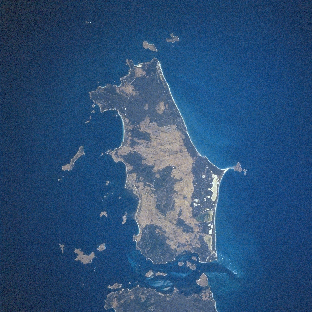 |
| STS081-749-014 Flinders Island, Tasmania, Australia January 1997 Flinders Island (approximately 40 miles long - 64 km and 29 miles - 47 km wide) is the largest island in the Furneaux Group. The islands extend northward from the northeast end of Tasmania into the Bass Strait. Except for the east coast, at least half of the island is made up of low mountains, primarily granite ridgelines and peaks. Strzelecki National Park, located at the southwest end of the island (dark, vegetated area), has the highest point on the island (Mt. Strzelecki is 2480 feet - 756 meters above sea level). The dark swath of land that borders the sandy beaches along the east coast shows a series of fresh and saline lagoons and swamps (varying colors and shapes) with old beach ridges further inland. The island's major sources of revenue are generated by agriculture (beef and dairy cattle as well as sheep ranching), fishing, and a growing tourist industry. The lighter-colored areas show where the agricultural lands are distributed throughout the island. Darker landscapes are indicative of mountainous features and naturally vegetated terrain. |
| Images: | All Available Images Low-Resolution 382k |
|
| Mission: | STS081 |
|
| Roll - Frame: | 749 - 14 |
|
| Geographical Name: | AUSTRALIA-T |
|
| Features: | FLINDERS ISLAND |
|
| Center Lat x Lon: | 40S x 148.0E |
|
| Film Exposure: | N | N=Normal exposure, U=Under exposed, O=Over exposed, F=out of Focus |
| Percentage of Cloud Cover-CLDP: | 0 |
|
| Camera:: | HB |
|
| Camera Tilt: | LO=Low Oblique, HO=High Oblique, NV=Near Vertical |
|
| Camera Focal Length: | 250 |
|
| Nadir to Photo Center Direction: | The direction from the nadir to the center point, N=North, S=South, E=East, W=West |
|
| Stereo?: | Y | Y=Yes there is an adjacent picture of the same area, N=No there isn't |
| Orbit Number: | |
|
| Date: | 199701__ | YYYYMMDD |
| Time: | GMT HHMMSS |
|
| Nadir Lat: | N |
Latitude of suborbital point of spacecraft |
| Nadir Lon: | E |
Longitude of suborbital point of spacecraft |
| Sun Azimuth: | Clockwise angle in degrees from north to the sun measured at the nadir point |
|
| Space Craft Altitude: | nautical miles |
|
| Sun Elevation: | Angle in degrees between the horizon and the sun, measured at the nadir point |
|
| Land Views: | ISLAND, MOUNTAIN, FOREST |
|
| Water Views: | |
|
| Atmosphere Views: | |
|
| Man Made Views: | AGRICULTURE |
|
| City Views: | |
|
Photo is not associated with any sequences | ||
| NASA Home Page |
JSC Home Page |
JSC Digital Image Collection |
Earth Science & Remote Sensing |
|
This service is provided by the International Space Station program and the JSC Earth Science & Remote Sensing Unit, ARES Division, Exploration Integration Science Directorate.

|