
Geographic Region: AUSTRALIA-T
Feature: FLINDERS ISLAND
|
Geographic Region: AUSTRALIA-T Feature: FLINDERS ISLAND |
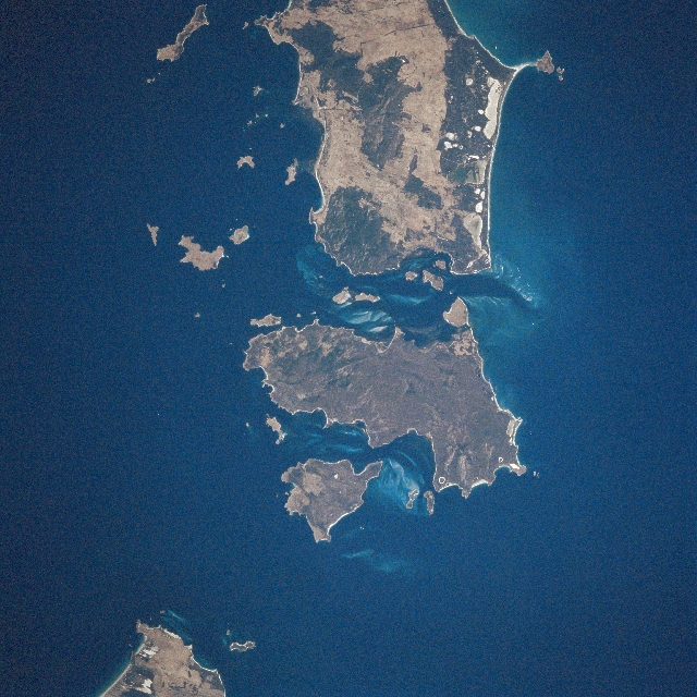 |
| STS081-749-013 Cape Barren Island, Tasmania, Australia January 1997 The Furneaux Group of islands, consisting of over 40 islands, extends northward from the northeast tip of Tasmania. The relationship of the three largest islands: Flinders (top center), Cape Barren (lower center), and Clarke (bottom center), with numerous smaller islands can be seen in this near-nadir view. Flinders Island is separated from Clarke Island by Armstrong Channel and Kent Bay. The surface topography is mountainous throughout the islands. Several granite peaks exceed 2000 feet (610 m) with many other peaks higher than 1300 feet (400 m) above sea level. The only major exception to the rugged mountains is along the east coast of Flinders Island where a broad, sandy plain prevails. The east coasts of Flinders and Cape Barren Islands also have coastal lagoons. Elevation differences coupled with varying rainfall amounts on the islands supports a variety of soil types and vegetation species. The vegetated landscape (darker areas) consists of grasslands, shrub land, woodland, and even forests. STS81-749-014 provides an entire view of Flinders Island. |
| Images: | All Available Images Low-Resolution 379k |
|
| Mission: | STS081 |
|
| Roll - Frame: | 749 - 13 |
|
| Geographical Name: | AUSTRALIA-T |
|
| Features: | FLINDERS ISLAND |
|
| Center Lat x Lon: | 40S x 148.0E |
|
| Film Exposure: | N | N=Normal exposure, U=Under exposed, O=Over exposed, F=out of Focus |
| Percentage of Cloud Cover-CLDP: | 0 |
|
| Camera:: | HB |
|
| Camera Tilt: | LO=Low Oblique, HO=High Oblique, NV=Near Vertical |
|
| Camera Focal Length: | 250 |
|
| Nadir to Photo Center Direction: | The direction from the nadir to the center point, N=North, S=South, E=East, W=West |
|
| Stereo?: | Y | Y=Yes there is an adjacent picture of the same area, N=No there isn't |
| Orbit Number: | |
|
| Date: | 199701__ | YYYYMMDD |
| Time: | GMT HHMMSS |
|
| Nadir Lat: | N |
Latitude of suborbital point of spacecraft |
| Nadir Lon: | E |
Longitude of suborbital point of spacecraft |
| Sun Azimuth: | Clockwise angle in degrees from north to the sun measured at the nadir point |
|
| Space Craft Altitude: | nautical miles |
|
| Sun Elevation: | Angle in degrees between the horizon and the sun, measured at the nadir point |
|
| Land Views: | ISLAND, MOUNTAIN |
|
| Water Views: | BAY, CHANNEL |
|
| Atmosphere Views: | |
|
| Man Made Views: | |
|
| City Views: | |
|
Photo is not associated with any sequences | ||
| NASA Home Page |
JSC Home Page |
JSC Digital Image Collection |
Earth Science & Remote Sensing |
|
This service is provided by the International Space Station program and the JSC Earth Science & Remote Sensing Unit, ARES Division, Exploration Integration Science Directorate.

|