
Geographic Region: CROATIA
Feature: BRAC ISLAND
|
Geographic Region: CROATIA Feature: BRAC ISLAND |
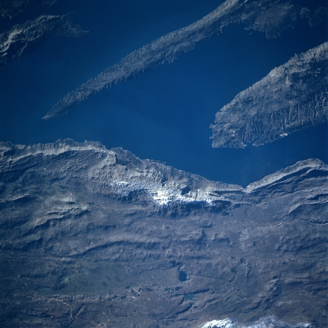 |
| STS081-747-34 Brac And Hvar Islands, Croatia January 1997 Extending from the upper right of the image, the long, narrow Hvar Island is visible in this southwest-looking view. The mountainous island covers an area of 111 square miles (288 square kilometers) and is forested. Grapes, olives, figs, and dates are grown in the island valleys. Marble is quarried. Fishing and tourism round out the economy of the island. North of Hvar Island in the upper right portion of the image is Brac Island (reference STS81-747-33). The rugged Dinaric Alps and the Dalmation Coast cover the bottom portion of the image. The Dinaric Alps, with its barren karst formations, divide the Dalmation Coast from the Bosnia-Herzegovina interior. With a moderate climate, the coastal regions are tourist areas. The coastal area is both rocky and sandy and the water is crystal clear to great depths. The Dalmation Coast has many bays and inlets. Snow covers the higher peaks of the Dinaric Alps. |
| Images: | All Available Images Low-Resolution 330k |
|
| Mission: | STS081 |
|
| Roll - Frame: | 747 - 34 |
|
| Geographical Name: | CROATIA |
|
| Features: | BRAC ISLAND |
|
| Center Lat x Lon: | 43.5N x 16.5E |
|
| Film Exposure: | N | N=Normal exposure, U=Under exposed, O=Over exposed, F=out of Focus |
| Percentage of Cloud Cover-CLDP: | 0 |
|
| Camera:: | HB |
|
| Camera Tilt: | LO=Low Oblique, HO=High Oblique, NV=Near Vertical |
|
| Camera Focal Length: | 250 |
|
| Nadir to Photo Center Direction: | The direction from the nadir to the center point, N=North, S=South, E=East, W=West |
|
| Stereo?: | Y | Y=Yes there is an adjacent picture of the same area, N=No there isn't |
| Orbit Number: | |
|
| Date: | 199701__ | YYYYMMDD |
| Time: | GMT HHMMSS |
|
| Nadir Lat: | N |
Latitude of suborbital point of spacecraft |
| Nadir Lon: | E |
Longitude of suborbital point of spacecraft |
| Sun Azimuth: | Clockwise angle in degrees from north to the sun measured at the nadir point |
|
| Space Craft Altitude: | nautical miles |
|
| Sun Elevation: | Angle in degrees between the horizon and the sun, measured at the nadir point |
|
| Land Views: | ISLAND, MOUNTAIN, COAST, FOREST |
|
| Water Views: | SEA, BAY, INLET |
|
| Atmosphere Views: | |
|
| Man Made Views: | MINING |
|
| City Views: | |
|
Photo is not associated with any sequences | ||
| NASA Home Page |
JSC Home Page |
JSC Digital Image Collection |
Earth Science & Remote Sensing |
|
This service is provided by the International Space Station program and the JSC Earth Science & Remote Sensing Unit, ARES Division, Exploration Integration Science Directorate.

|