
Geographic Region: CROATIA
Feature: BRAC ISLAND
|
Geographic Region: CROATIA Feature: BRAC ISLAND |
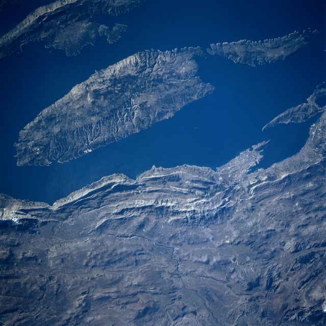 |
| STS081-747-033 Brac Island, Croatia January 1997 The largest of the Dalmation Islands, Brac Island can be seen in this southwest-looking view. Brac Island covers an area of 152 square miles (394 square km) and is separated 12 miles (19 km) from the mainland by a channel. The island is mountainous and wooded. Vineyards in the valleys produce excellent wine. Fishing and fish canneries are important to the island's economy as are the marble and slate quarries and asphalt deposits. The island of Brac is also a popular vacation center with many summer resorts along the coast. A small portion of Hvar Island is visible in the upper left portion of the image. A section of the Dinaric Alps cover the bottom half of the image. The rugged coastal area has many bays and inlets and is a tourist region. |
| Images: | All Available Images Low-Resolution 354k |
|
| Mission: | STS081 |
|
| Roll - Frame: | 747 - 33 |
|
| Geographical Name: | CROATIA |
|
| Features: | BRAC ISLAND |
|
| Center Lat x Lon: | 43.5N x 16.5E |
|
| Film Exposure: | N | N=Normal exposure, U=Under exposed, O=Over exposed, F=out of Focus |
| Percentage of Cloud Cover-CLDP: | 0 |
|
| Camera:: | HB |
|
| Camera Tilt: | LO=Low Oblique, HO=High Oblique, NV=Near Vertical |
|
| Camera Focal Length: | 250 |
|
| Nadir to Photo Center Direction: | The direction from the nadir to the center point, N=North, S=South, E=East, W=West |
|
| Stereo?: | Y | Y=Yes there is an adjacent picture of the same area, N=No there isn't |
| Orbit Number: | |
|
| Date: | 199701__ | YYYYMMDD |
| Time: | GMT HHMMSS |
|
| Nadir Lat: | N |
Latitude of suborbital point of spacecraft |
| Nadir Lon: | E |
Longitude of suborbital point of spacecraft |
| Sun Azimuth: | Clockwise angle in degrees from north to the sun measured at the nadir point |
|
| Space Craft Altitude: | nautical miles |
|
| Sun Elevation: | Angle in degrees between the horizon and the sun, measured at the nadir point |
|
| Land Views: | ISLAND, MOUNTAIN |
|
| Water Views: | SEA, BAY |
|
| Atmosphere Views: | |
|
| Man Made Views: | MINING |
|
| City Views: | |
|
Photo is not associated with any sequences | ||
| NASA Home Page |
JSC Home Page |
JSC Digital Image Collection |
Earth Science & Remote Sensing |
|
This service is provided by the International Space Station program and the JSC Earth Science & Remote Sensing Unit, ARES Division, Exploration Integration Science Directorate.

|