
Geographic Region: CROATIA
Feature: PULA, PENINSULA
|
Geographic Region: CROATIA Feature: PULA, PENINSULA |
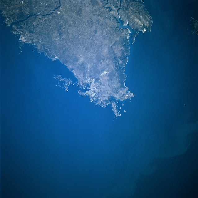 |
| STS081-747-031 Istrian Peninsula, Pula, Croatia January 1997 The southern portion of the mountainous Istrian Peninsula can be seen in this northeast-looking view. The peninsula sits between the Gulf of Venice to the west (left) and the Gulf of Flume to the east (right). Much of the peninsula is thickly forested and is predominantly agricultural. The city of Pula, near the southern tip of the Istrian Peninsula, is a major seaport and an industrial center. Shipbuilding is a major industry in Pula. The city also has a major naval base. |
| Images: | All Available Images Low-Resolution 289k |
|
| Mission: | STS081 |
|
| Roll - Frame: | 747 - 31 |
|
| Geographical Name: | CROATIA |
|
| Features: | PULA, PENINSULA |
|
| Center Lat x Lon: | 45.0N x 14.0E |
|
| Film Exposure: | N | N=Normal exposure, U=Under exposed, O=Over exposed, F=out of Focus |
| Percentage of Cloud Cover-CLDP: | 0 |
|
| Camera:: | HB |
|
| Camera Tilt: | LO=Low Oblique, HO=High Oblique, NV=Near Vertical |
|
| Camera Focal Length: | 250 |
|
| Nadir to Photo Center Direction: | The direction from the nadir to the center point, N=North, S=South, E=East, W=West |
|
| Stereo?: | Y | Y=Yes there is an adjacent picture of the same area, N=No there isn't |
| Orbit Number: | |
|
| Date: | 199701__ | YYYYMMDD |
| Time: | GMT HHMMSS |
|
| Nadir Lat: | N |
Latitude of suborbital point of spacecraft |
| Nadir Lon: | E |
Longitude of suborbital point of spacecraft |
| Sun Azimuth: | Clockwise angle in degrees from north to the sun measured at the nadir point |
|
| Space Craft Altitude: | nautical miles |
|
| Sun Elevation: | Angle in degrees between the horizon and the sun, measured at the nadir point |
|
| Land Views: | PENINSULA, HILL |
|
| Water Views: | SEA |
|
| Atmosphere Views: | |
|
| Man Made Views: | AGRICULTURE |
|
| City Views: | |
|
Photo is not associated with any sequences | ||
| NASA Home Page |
JSC Home Page |
JSC Digital Image Collection |
Earth Science & Remote Sensing |
|
This service is provided by the International Space Station program and the JSC Earth Science & Remote Sensing Unit, ARES Division, Exploration Integration Science Directorate.

|