Geographic Region: CHILE
Feature: ANDES, LAKE LAIA
|
Geographic Region: CHILE Feature: ANDES, LAKE LAIA |
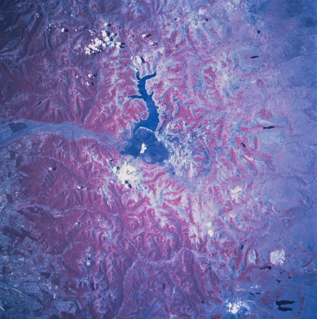 |
| STS081-742-071 Laguna de la Laja, Chile January 1997 Laguna de la Laja is the sinuous dark feature in the middle of this color infrared image of the Andes range east of Los Angeles, Chile. From a hydroelectric generating station at the southwest end of the reservoir, Rio Laja flows westward down a broad valley cut through the Andes. The rough-textured, dark, arcuate feature at the south end of the reservoir is a large lava field. The amount of vegetative cover differs dramatically between the east and the west slopes of the Andes. This image illustrates the "rain shadow effect" where moisture-bearing westerly winds off the Pacific cross the mountains and produce well-watered, densely forested western slopes (deeper red indicates heavier vegetation). The eastern slopes receive less moisture and are less vegetated, thus the gradation from deep red to lighter pink from west to east across the color infrared image. The dark, U-shaped feature in the bottom right corner is Lago Agrio and the lighter colored feature immediately west of this lake is Copahue Volcano. |
| Images: | All Available Images Low-Resolution 376k |
|
| Mission: | STS081 |
|
| Roll - Frame: | 742 - 71 |
|
| Geographical Name: | CHILE |
|
| Features: | ANDES, LAKE LAIA |
|
| Center Lat x Lon: | 37.5S x 71.5W |
|
| Film Exposure: | N | N=Normal exposure, U=Under exposed, O=Over exposed, F=out of Focus |
| Percentage of Cloud Cover-CLDP: | 5 |
|
| Camera:: | HB |
|
| Camera Tilt: | 22 | LO=Low Oblique, HO=High Oblique, NV=Near Vertical |
| Camera Focal Length: | 100 |
|
| Nadir to Photo Center Direction: | SW | The direction from the nadir to the center point, N=North, S=South, E=East, W=West |
| Stereo?: | Y | Y=Yes there is an adjacent picture of the same area, N=No there isn't |
| Orbit Number: | 132 |
|
| Date: | 19970120 | YYYYMMDD |
| Time: | 181311 | GMT HHMMSS |
| Nadir Lat: | 36.8S |
Latitude of suborbital point of spacecraft |
| Nadir Lon: | 70.3W |
Longitude of suborbital point of spacecraft |
| Sun Azimuth: | 308 | Clockwise angle in degrees from north to the sun measured at the nadir point |
| Space Craft Altitude: | 205 | nautical miles |
| Sun Elevation: | 66 | Angle in degrees between the horizon and the sun, measured at the nadir point |
| Land Views: | MOUNTAIN, VOLCANO |
|
| Water Views: | LAGOON, RIVER |
|
| Atmosphere Views: | |
|
| Man Made Views: | |
|
| City Views: | |
|
Photo is not associated with any sequences | ||
| NASA Home Page |
JSC Home Page |
JSC Digital Image Collection |
Earth Science & Remote Sensing |
|
This service is provided by the International Space Station program and the JSC Earth Science & Remote Sensing Unit, ARES Division, Exploration Integration Science Directorate.

|