Geographic Region: COSTA RICA
Feature: NICOYA PENINSULA
|
Geographic Region: COSTA RICA Feature: NICOYA PENINSULA |
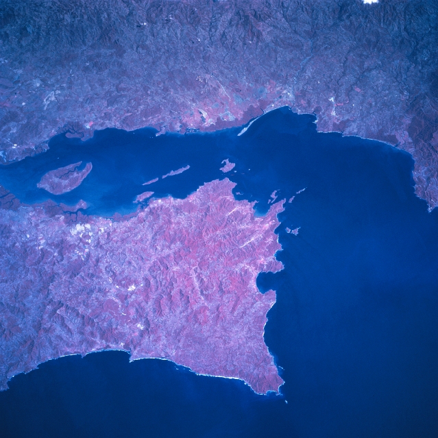 |
| STS081-742-030 Nicoya Gulf, Peninsula, Costa Rica January 1997 The southern end of the mountainous Nicoya Peninsula extends southeasterly separating the waters of the Pacific Ocean from the Gulf of Nicoya. The color infrared image helps to document the numerous vegetated hills and valleys (red colors represent green plants) both on the peninsula as well as on the mainland. The deeper reds tend to show either dense stands of rainforest or in the coastal zone, they represent mangrove forests. The small estuary of the Rio Grande de Tarcoles is barely discernible near the upper right edge (southeast corner) of the image. Chira Island is the large island in the Gulf of Nicoya. (Refer to STS81-742-028 and STS81-742-029 for other color infrared pictures of the Nicoya Peninsula). |
| Images: | All Available Images Low-Resolution 333k |
|
| Mission: | STS081 |
|
| Roll - Frame: | 742 - 30 |
|
| Geographical Name: | COSTA RICA |
|
| Features: | NICOYA PENINSULA |
|
| Center Lat x Lon: | 10.0N x 85W |
|
| Film Exposure: | N | N=Normal exposure, U=Under exposed, O=Over exposed, F=out of Focus |
| Percentage of Cloud Cover-CLDP: | 0 |
|
| Camera:: | HB |
|
| Camera Tilt: | 26 | LO=Low Oblique, HO=High Oblique, NV=Near Vertical |
| Camera Focal Length: | 250 |
|
| Nadir to Photo Center Direction: | NE | The direction from the nadir to the center point, N=North, S=South, E=East, W=West |
| Stereo?: | Y | Y=Yes there is an adjacent picture of the same area, N=No there isn't |
| Orbit Number: | 131 |
|
| Date: | 19970120 | YYYYMMDD |
| Time: | 162556 | GMT HHMMSS |
| Nadir Lat: | 8.9N |
Latitude of suborbital point of spacecraft |
| Nadir Lon: | 86.1W |
Longitude of suborbital point of spacecraft |
| Sun Azimuth: | 143 | Clockwise angle in degrees from north to the sun measured at the nadir point |
| Space Craft Altitude: | 193 | nautical miles |
| Sun Elevation: | 54 | Angle in degrees between the horizon and the sun, measured at the nadir point |
| Land Views: | PENINSULA, MOUNTAIN, ISLAND |
|
| Water Views: | GULF |
|
| Atmosphere Views: | |
|
| Man Made Views: | |
|
| City Views: | |
|
Photo is not associated with any sequences | ||
| NASA Home Page |
JSC Home Page |
JSC Digital Image Collection |
Earth Science & Remote Sensing |
|
This service is provided by the International Space Station program and the JSC Earth Science & Remote Sensing Unit, ARES Division, Exploration Integration Science Directorate.

|