
Geographic Region: COSTA RICA
Feature: NICOYA PENINSULA, AGR.
|
Geographic Region: COSTA RICA Feature: NICOYA PENINSULA, AGR. |
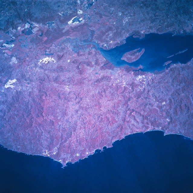 |
| STS081-742-029 Nicoya Peninsula, Costa Rica January 1997 Missing only the southern end of the Nicoya Peninsula, this color infrared image includes most of the low mountainous terrain that makes up this rugged peninsula. Since this picture is a color infrared image, the darker reds indicate an abundance of vegetative cover (in some areas even a rainforest environment exists) over the landscape. The deep reds near the mouth of the Tempisque River, shows an extensive region of low-lying swamplands and tidal marshes. Some of the darker areas around the Gulf of Nicoya include large stands of mangrove forests. The highly reflective areas and the large angular-looking field patterns are human induced development activities-either mining or agricultural endeavors. The coastline that faces the Pacific Ocean is irregular with numerous small bays and steeply sloping cliffs. Chira Island is the large island in the Gulf of Nicoya. (Refer to STS81-742-028 and STS81-742-030 for other color infrared images of the Nicoya Peninsula). |
| Images: | All Available Images Low-Resolution 354k |
|
| Mission: | STS081 |
|
| Roll - Frame: | 742 - 29 |
|
| Geographical Name: | COSTA RICA |
|
| Features: | NICOYA PENINSULA, AGR. |
|
| Center Lat x Lon: | 10.5N x 85.5W |
|
| Film Exposure: | N | N=Normal exposure, U=Under exposed, O=Over exposed, F=out of Focus |
| Percentage of Cloud Cover-CLDP: | 0 |
|
| Camera:: | HB |
|
| Camera Tilt: | 26 | LO=Low Oblique, HO=High Oblique, NV=Near Vertical |
| Camera Focal Length: | 250 |
|
| Nadir to Photo Center Direction: | NE | The direction from the nadir to the center point, N=North, S=South, E=East, W=West |
| Stereo?: | Y | Y=Yes there is an adjacent picture of the same area, N=No there isn't |
| Orbit Number: | 131 |
|
| Date: | 19970120 | YYYYMMDD |
| Time: | 162553 | GMT HHMMSS |
| Nadir Lat: | 9.1N |
Latitude of suborbital point of spacecraft |
| Nadir Lon: | 86.2W |
Longitude of suborbital point of spacecraft |
| Sun Azimuth: | 143 | Clockwise angle in degrees from north to the sun measured at the nadir point |
| Space Craft Altitude: | 193 | nautical miles |
| Sun Elevation: | 53 | Angle in degrees between the horizon and the sun, measured at the nadir point |
| Land Views: | PENINSULA, MOUNTAIN |
|
| Water Views: | RIVER, GULF |
|
| Atmosphere Views: | |
|
| Man Made Views: | AGRICULTURE |
|
| City Views: | |
|
Photo is not associated with any sequences | ||
| NASA Home Page |
JSC Home Page |
JSC Digital Image Collection |
Earth Science & Remote Sensing |
|
This service is provided by the International Space Station program and the JSC Earth Science & Remote Sensing Unit, ARES Division, Exploration Integration Science Directorate.

|