 Photo #: STS081-742-28 Date: Jan. 1997
Geographic Region: COSTA RICA
Feature: NICOYA PENINSULA, AGR.

 Photo #: STS081-742-28 Date: Jan. 1997 Photo #: STS081-742-28 Date: Jan. 1997Geographic Region: COSTA RICA Feature: NICOYA PENINSULA, AGR. |
 |
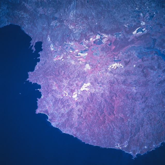
| STS081-742-028 Tempisque River Basin, Costa Rica January 1997 The broadest part of the Nicoya Peninsula where it attaches to the mainland is featured in this color infrared picture (green vegetation is presented in red colors) of the northwest coast of Costa Rica. This region has been developed by a series of up-faulted blocks creating a mountainous peninsula, with many indented shorelines, and a steep, rocky coastline. The lowland area immediately northeast of the peninsula is the Tempisque River Basin. The main channel of the river can be traced across the image (mainly as a thin, dark line) as the river first flows south and then makes a turn southeast, finally emptying into the Gulf of Nicoya (off the right edge of the picture). The Tempisque River and its tributaries have produced an extensive lowland alluvial plain. Large field patterns are visible on the higher elevations of this fertile plain, especially on the northeast side of the river, where tropical lowland agriculture flourishes--including ranching and plantation activities. The darker areas near the delta and mouth of the Tempisque River shows an extensive area of low-lying swamps and lagoons, many of which are saline in nature. (Refer to STS82-742-029 and STS81-742-030 for a continuation of images along the Nicoya Peninsula in Costa Rica). |
| Images: | All Available Images Low-Resolution 352k |
|
| Mission: | STS081 |
|
| Roll - Frame: | 742 - 28 |
|
| Geographical Name: | COSTA RICA |
|
| Features: | NICOYA PENINSULA, AGR. |
|
| Center Lat x Lon: | 10.5N x 85.5W |
|
| Film Exposure: | N | N=Normal exposure, U=Under exposed, O=Over exposed, F=out of Focus |
| Percentage of Cloud Cover-CLDP: | 0 |
|
| Camera:: | HB |
|
| Camera Tilt: | 25 | LO=Low Oblique, HO=High Oblique, NV=Near Vertical |
| Camera Focal Length: | 250 |
|
| Nadir to Photo Center Direction: | NE | The direction from the nadir to the center point, N=North, S=South, E=East, W=West |
| Stereo?: | Y | Y=Yes there is an adjacent picture of the same area, N=No there isn't |
| Orbit Number: | 131 |
|
| Date: | 19970120 | YYYYMMDD |
| Time: | 162551 | GMT HHMMSS |
| Nadir Lat: | 9.2N |
Latitude of suborbital point of spacecraft |
| Nadir Lon: | 86.3W |
Longitude of suborbital point of spacecraft |
| Sun Azimuth: | 143 | Clockwise angle in degrees from north to the sun measured at the nadir point |
| Space Craft Altitude: | 193 | nautical miles |
| Sun Elevation: | 53 | Angle in degrees between the horizon and the sun, measured at the nadir point |
| Land Views: | MOUNTAIN, COAST, VALLEY |
|
| Water Views: | RIVER |
|
| Atmosphere Views: | |
|
| Man Made Views: | AGRICULTURE |
|
| City Views: | |
|
Photo is not associated with any sequences | ||
| NASA Home Page |
JSC Home Page |
JSC Digital Image Collection |
Earth Science & Remote Sensing |
|
|