
Geographic Region: NICARAGUA
Feature: LAKE NICARAGUA
|
Geographic Region: NICARAGUA Feature: LAKE NICARAGUA |
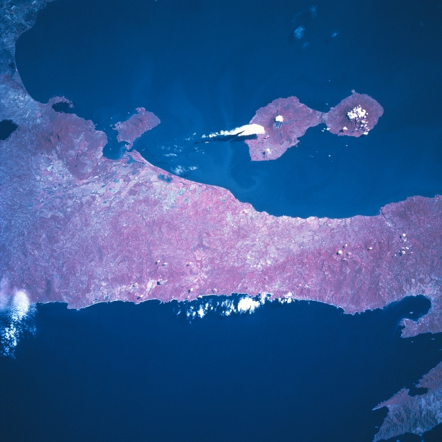 |
| STS081-742-025 Ometepe Island, Nicaragua January 1997 Ometepe Island, formed by two volcanoes, is located along the west side of Lake Nicaragua. Conception Volcano, an active volcano, makes up the larger, northwest part of the island, while Maderas Volcano on the southeast side of the island is dormant. Their respective summit elevations are 5283 feet (1610 meters) and 4413 feet (1345 meters) above sea level. Several small towns are distributed around the island. The major economic activities include tourism, farming, and ranching, with tourism the major attraction. The color infrared image (records healthy green vegetation as various shades of red) helps to identify the distribution of the natural vegetation and also helps to delimit land-water boundaries. Most of the remaining tropical rainforest (darker reds) are found on the Maderas side of the island. The strip of land that separates Lake Nicaragua from the Pacific Ocean is about 12 miles (19 km) in width. The narrow corridor of land shows some agricultural activity (lighter colored areas) and a forested landscape (darker reds). |
| Images: | All Available Images Low-Resolution 302k |
|
| Mission: | STS081 |
|
| Roll - Frame: | 742 - 25 |
|
| Geographical Name: | NICARAGUA |
|
| Features: | LAKE NICARAGUA |
|
| Center Lat x Lon: | 11.0N x 86W |
|
| Film Exposure: | N | N=Normal exposure, U=Under exposed, O=Over exposed, F=out of Focus |
| Percentage of Cloud Cover-CLDP: | 5 |
|
| Camera:: | HB |
|
| Camera Tilt: | 26 | LO=Low Oblique, HO=High Oblique, NV=Near Vertical |
| Camera Focal Length: | 250 |
|
| Nadir to Photo Center Direction: | N | The direction from the nadir to the center point, N=North, S=South, E=East, W=West |
| Stereo?: | Y | Y=Yes there is an adjacent picture of the same area, N=No there isn't |
| Orbit Number: | 131 |
|
| Date: | 19970120 | YYYYMMDD |
| Time: | 162545 | GMT HHMMSS |
| Nadir Lat: | 9.5N |
Latitude of suborbital point of spacecraft |
| Nadir Lon: | 86.5W |
Longitude of suborbital point of spacecraft |
| Sun Azimuth: | 143 | Clockwise angle in degrees from north to the sun measured at the nadir point |
| Space Craft Altitude: | 193 | nautical miles |
| Sun Elevation: | 53 | Angle in degrees between the horizon and the sun, measured at the nadir point |
| Land Views: | VOLCANO, ISLAND |
|
| Water Views: | LAKE, OCEAN |
|
| Atmosphere Views: | |
|
| Man Made Views: | |
|
| City Views: | |
|
Photo is not associated with any sequences | ||
| NASA Home Page |
JSC Home Page |
JSC Digital Image Collection |
Earth Science & Remote Sensing |
|
This service is provided by the International Space Station program and the JSC Earth Science & Remote Sensing Unit, ARES Division, Exploration Integration Science Directorate.

|