
Geographic Region: NICARAGUA
Feature: LAKE MANAGUA
|
Geographic Region: NICARAGUA Feature: LAKE MANAGUA |
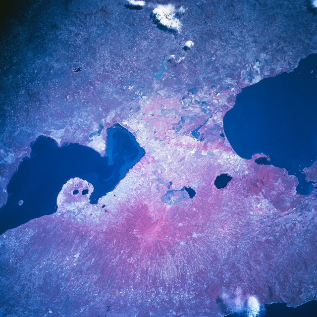 |
| STS081-742-23 Lake Managua, Nicaragua January 1997 The dark-looking water of Lake Managua (left middle) and the northwest end of Lake Nicaragua (right middle) stand out in marked contrast with the volcanic landscape of western Nicaragua in this color infrared image. Most of the land between the two lakes is used for agriculture (note the cultivated field patterns). There is a light colored sediment plume in the water along the east shore of Lake Managua. The smaller dark features that are aligned northwest to southeast display the location of four craters/calderas that have been filled with water. These water-filled structures help to identify the active volcanic belt that borders and parallels the west coast of Central America. The capital of Nicaragua, Managua, is the highly reflective (lighter in color) area south of Lake Managua. Masaya Volcano, a composite twin volcano with multiple summit craters and a caldera lake along the east side of the volcano, is discernible southeast of the city of Managua (slightly below the center of the image). Notice how the color infrared picture (green vegetation is portrayed as reddish colors) helps to document the deeply eroded western flanks of the low mountains in the lower third of the picture. |
| Images: | All Available Images Low-Resolution 381k |
|
| Mission: | STS081 |
|
| Roll - Frame: | 742 - 23 |
|
| Geographical Name: | NICARAGUA |
|
| Features: | LAKE MANAGUA |
|
| Center Lat x Lon: | 12.0N x 86W |
|
| Film Exposure: | N | N=Normal exposure, U=Under exposed, O=Over exposed, F=out of Focus |
| Percentage of Cloud Cover-CLDP: | 5 |
|
| Camera:: | HB |
|
| Camera Tilt: | 37 | LO=Low Oblique, HO=High Oblique, NV=Near Vertical |
| Camera Focal Length: | 250 |
|
| Nadir to Photo Center Direction: | N | The direction from the nadir to the center point, N=North, S=South, E=East, W=West |
| Stereo?: | Y | Y=Yes there is an adjacent picture of the same area, N=No there isn't |
| Orbit Number: | 131 |
|
| Date: | 19970120 | YYYYMMDD |
| Time: | 162540 | GMT HHMMSS |
| Nadir Lat: | 9.7N |
Latitude of suborbital point of spacecraft |
| Nadir Lon: | 86.7W |
Longitude of suborbital point of spacecraft |
| Sun Azimuth: | 143 | Clockwise angle in degrees from north to the sun measured at the nadir point |
| Space Craft Altitude: | 193 | nautical miles |
| Sun Elevation: | 53 | Angle in degrees between the horizon and the sun, measured at the nadir point |
| Land Views: | VOLCANO, CALDERA, MOUNTAIN |
|
| Water Views: | LAKE |
|
| Atmosphere Views: | |
|
| Man Made Views: | AGRICULTURE |
|
| City Views: | |
|
Photo is not associated with any sequences | ||
| NASA Home Page |
JSC Home Page |
JSC Digital Image Collection |
Earth Science & Remote Sensing |
|
This service is provided by the International Space Station program and the JSC Earth Science & Remote Sensing Unit, ARES Division, Exploration Integration Science Directorate.

|