
Geographic Region: BAHAMAS
Feature: ELEUTHERA ISLAND
|
Geographic Region: BAHAMAS Feature: ELEUTHERA ISLAND |
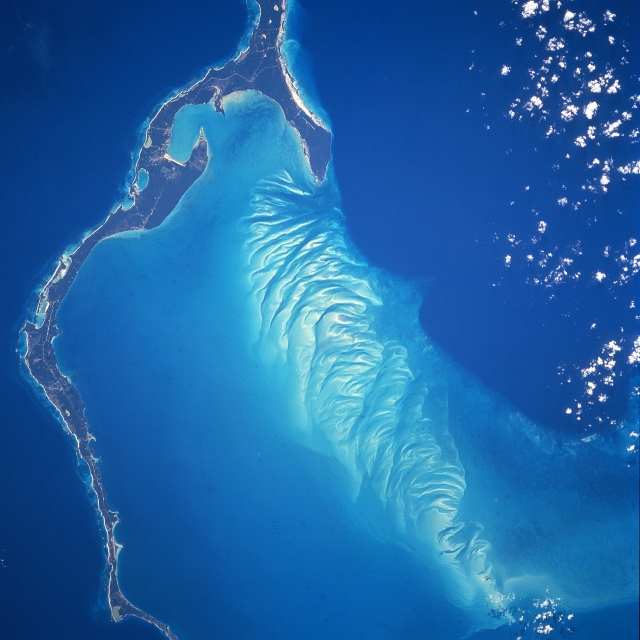 |
| STS081-738-066 Eleuthera Island, Bahamas January 1997 The long, narrow Eleuthera Island can be seen in this mostly south-looking view. Like most of the Bahama Islands, Eleuthera is composed mainly of limestone and coral, and rises from a vast submarine plateau. The island, 80 miles (133 km) long, 2 miles (3 km) wide and covering an area of 164 sq. miles (425 sq. km), is generally low and flat, river- less, and has many mangrove swamps, brackish lakes, coral reefs and shoals, and many miles (km) of sandy beaches. Eleuthera, which means "Freedom" in Greek, was one of the earliest islands within the Bahamas to be colonized. Approximately 11000 people inhabit the island, which must get its fresh water from either rainfall or desalinazation. Hurricanes can occasionally cause severe damage to residences on the island. Eleuthera is a popular vacation resort area. |
| Images: | All Available Images Low-Resolution 301k |
|
| Mission: | STS081 |
|
| Roll - Frame: | 738 - 66 |
|
| Geographical Name: | BAHAMAS |
|
| Features: | ELEUTHERA ISLAND |
|
| Center Lat x Lon: | 25.0N x 76.5W |
|
| Film Exposure: | N | N=Normal exposure, U=Under exposed, O=Over exposed, F=out of Focus |
| Percentage of Cloud Cover-CLDP: | 5 |
|
| Camera:: | HB |
|
| Camera Tilt: | 9 | LO=Low Oblique, HO=High Oblique, NV=Near Vertical |
| Camera Focal Length: | 250 |
|
| Nadir to Photo Center Direction: | W | The direction from the nadir to the center point, N=North, S=South, E=East, W=West |
| Stereo?: | Y | Y=Yes there is an adjacent picture of the same area, N=No there isn't |
| Orbit Number: | 130 |
|
| Date: | 19970120 | YYYYMMDD |
| Time: | 144848 | GMT HHMMSS |
| Nadir Lat: | 25.1N |
Latitude of suborbital point of spacecraft |
| Nadir Lon: | 76W |
Longitude of suborbital point of spacecraft |
| Sun Azimuth: | 138 | Clockwise angle in degrees from north to the sun measured at the nadir point |
| Space Craft Altitude: | 188 | nautical miles |
| Sun Elevation: | 33 | Angle in degrees between the horizon and the sun, measured at the nadir point |
| Land Views: | ISLAND, COAST |
|
| Water Views: | OCEAN |
|
| Atmosphere Views: | |
|
| Man Made Views: | |
|
| City Views: | |
|
Photo is not associated with any sequences | ||
| NASA Home Page |
JSC Home Page |
JSC Digital Image Collection |
Earth Science & Remote Sensing |
|
This service is provided by the International Space Station program and the JSC Earth Science & Remote Sensing Unit, ARES Division, Exploration Integration Science Directorate.

|