Geographic Region: ARGENTINA
Feature: PLANICIE BANDERITA LAKE
|
Geographic Region: ARGENTINA Feature: PLANICIE BANDERITA LAKE |
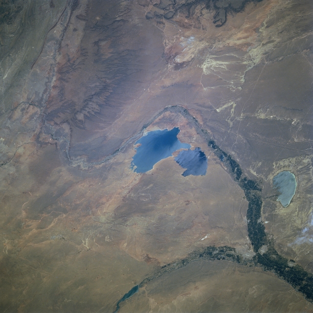 |
| STS081-728-089 Cerros Colorados Reservoir, Argentina January 1997 The large double water body in the center of the image, the Cerros Colorados Reservoir, is located on the Patagonian Plateau in south-central Argentina. The reservoir was formed in a natural depression in the plateau by diverting water from the Rio Neuquen for flood control purposes. The two lakes identified with this reservoir are Lago Barriales (larger) and Lago Mari Menuco. Cultivated fields (vegetation) on the floodplains of the Neuquen and Limay Rivers appear as dark corridors crossing the pale brown, semiarid, shrubby landscape. Eastward from the junction of these two rivers, the river is known as the Negro. The kidney-shaped feature along the right edge of the image is Lago Pellegrini, a eutrophic lake. The light-colored areas around Lago Pellegrini are sandy, saline soils. Note the well-defined, dense pattern of gullies along the flank of the plateau (brownish feature top left) west of the Cerros Colorados Reservoir. |
| Images: | All Available Images Low-Resolution 306k |
|
| Mission: | STS081 |
|
| Roll - Frame: | 728 - 89 |
|
| Geographical Name: | ARGENTINA |
|
| Features: | PLANICIE BANDERITA LAKE |
|
| Center Lat x Lon: | 39S x 69W |
|
| Film Exposure: | N | N=Normal exposure, U=Under exposed, O=Over exposed, F=out of Focus |
| Percentage of Cloud Cover-CLDP: | 0 |
|
| Camera:: | HB |
|
| Camera Tilt: | 54 | LO=Low Oblique, HO=High Oblique, NV=Near Vertical |
| Camera Focal Length: | 250 |
|
| Nadir to Photo Center Direction: | W | The direction from the nadir to the center point, N=North, S=South, E=East, W=West |
| Stereo?: | Y | Y=Yes there is an adjacent picture of the same area, N=No there isn't |
| Orbit Number: | 132 |
|
| Date: | 19970120 | YYYYMMDD |
| Time: | 181443 | GMT HHMMSS |
| Nadir Lat: | 40.5S |
Latitude of suborbital point of spacecraft |
| Nadir Lon: | 64.5W |
Longitude of suborbital point of spacecraft |
| Sun Azimuth: | 304 | Clockwise angle in degrees from north to the sun measured at the nadir point |
| Space Craft Altitude: | 206 | nautical miles |
| Sun Elevation: | 60 | Angle in degrees between the horizon and the sun, measured at the nadir point |
| Land Views: | FLOOD PLAIN, DESERT |
|
| Water Views: | RESERVOIR, RIVER |
|
| Atmosphere Views: | |
|
| Man Made Views: | |
|
| City Views: | |
|
Photo is not associated with any sequences | ||
| NASA Home Page |
JSC Home Page |
JSC Digital Image Collection |
Earth Science & Remote Sensing |
|
This service is provided by the International Space Station program and the JSC Earth Science & Remote Sensing Unit, ARES Division, Exploration Integration Science Directorate.

|