Geographic Region: ARGENTINA
Feature: RAMOS MEXIA RESERVOIR
|
Geographic Region: ARGENTINA Feature: RAMOS MEXIA RESERVOIR |
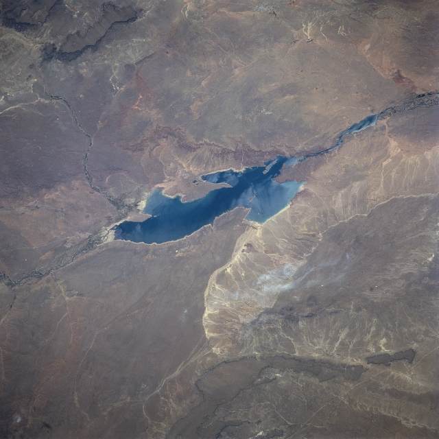 |
| STS081-728-088 Ezequil Ramos Mexia Reservoir, Argentina January 1997 There are two separate reservoirs along this section of the Rio Limay in northern Patagonia. Ezequiel Ramos Mexia (bluish feature) is the large reservoir in the center of the image; the smaller Arroyito Reservoir is farther downstream (northeast) on the Rio Limay. The "Ramos Mexia" Reservoir, also known as "El Chocon", was constructed to serve multiple purposes such as flood control, hydroelectric power, provide water for irrigation, and for sports fishing and recreation. The city of Neuquen, a regional center for petroleum exploration, is in the Limay valley at the right edge of the frame. Although the surrounding region is arid with xerophilic vegetation and shrubby bushes, floodplains of many rivers and streams support agriculture. Agricultural field patterns are visible in the valleys in this picture. |
| Images: | All Available Images Low-Resolution 316k |
|
| Mission: | STS081 |
|
| Roll - Frame: | 728 - 88 |
|
| Geographical Name: | ARGENTINA |
|
| Features: | RAMOS MEXIA RESERVOIR |
|
| Center Lat x Lon: | 39.5S x 69.5W |
|
| Film Exposure: | N | N=Normal exposure, U=Under exposed, O=Over exposed, F=out of Focus |
| Percentage of Cloud Cover-CLDP: | 0 |
|
| Camera:: | HB |
|
| Camera Tilt: | 53 | LO=Low Oblique, HO=High Oblique, NV=Near Vertical |
| Camera Focal Length: | 250 |
|
| Nadir to Photo Center Direction: | W | The direction from the nadir to the center point, N=North, S=South, E=East, W=West |
| Stereo?: | Y | Y=Yes there is an adjacent picture of the same area, N=No there isn't |
| Orbit Number: | 132 |
|
| Date: | 19970120 | YYYYMMDD |
| Time: | 181435 | GMT HHMMSS |
| Nadir Lat: | 40.2S |
Latitude of suborbital point of spacecraft |
| Nadir Lon: | 65W |
Longitude of suborbital point of spacecraft |
| Sun Azimuth: | 305 | Clockwise angle in degrees from north to the sun measured at the nadir point |
| Space Craft Altitude: | 205 | nautical miles |
| Sun Elevation: | 60 | Angle in degrees between the horizon and the sun, measured at the nadir point |
| Land Views: | FLOOD PLAIN, DESERT |
|
| Water Views: | RESERVOIR, RIVER |
|
| Atmosphere Views: | |
|
| Man Made Views: | |
|
| City Views: | |
|
Photo is not associated with any sequences | ||
| NASA Home Page |
JSC Home Page |
JSC Digital Image Collection |
Earth Science & Remote Sensing |
|
This service is provided by the International Space Station program and the JSC Earth Science & Remote Sensing Unit, ARES Division, Exploration Integration Science Directorate.

|